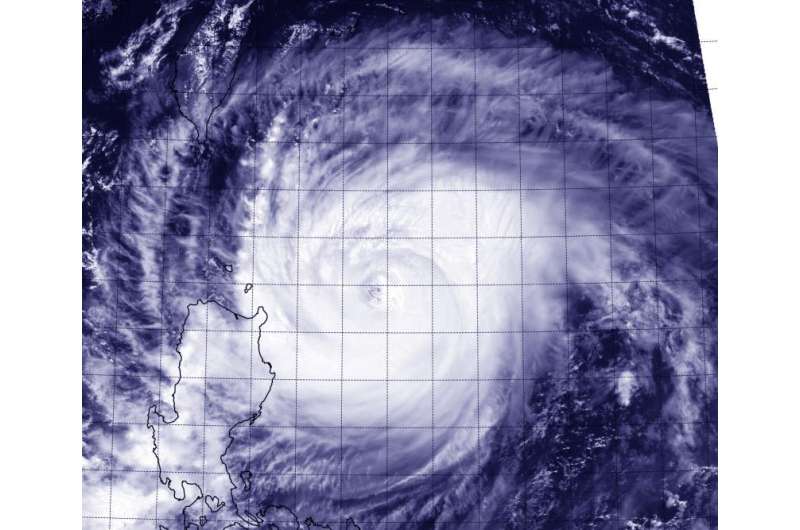
Suomi NPP Satellite sees Typhoon Goni brush northeastern Philippines

Typhoon Goni appeared to be brushing Luzon, the northeastern Philippines in imagery from NASA-NOAA's Suomi NPP Satellite on August 20.
On August 20 at 0521 UTC (1:21 a.m. EDT), NASA-NOAA's Suomi NPP satellite passed over Typhoon Goni. The Visible Infrared Imaging Radiometer Suite (VIIRS) instrument aboard Suomi satellite captured a visible image of Goni that showed the southwestern edge of the storm skirting the northwestern Luzon region. Powerful, thick bands of thunderstorms spiraled around Goni's eye.
There are numerous warnings in effect in the Philippines on August 20. They include Public storm warning signal #3 in the Batanes Group of Islands, northern Cagayan including Calayan and Babuyan Group of Islands. Public storm warning signal #2 is effect in the rest of Cagayan are, northern Isabela, Kalinga, Apayao, Abra, Ilocos Norte. In addition, Public storm warning signal #1 is effect in for the rest of Isabela, northern Aurora, Quirino, Nueva Vizcaya, Ifugao, Mt Province, Benguet, La Union and Ilocos Sur.
At 0900 UTC (5 a.m. EDT) on August 20, Typhoon Goni had maximum sustained winds near 115 knots (132.3 mph/213 kph). It was centered near 18.9 North latitude and 124.6 East longitude, about 331 nautical miles (380.9 miles/613 km) northeast of Manila, Philippines. Goni was moving to the west at 7 knots (8 mph/12.9 kph).
The Joint Typhoon Warning Center expects Goni to continue strengthening to 120 knots (138.1 mph/222.2 kph) before beginning to weaken on August 21 and curving sharply to the north, passing east of Taiwan. Thereafter, the JTWC expects Goni to curve to the northeast.
Provided by NASA's Goddard Space Flight Center


