Snow cover hits record lows

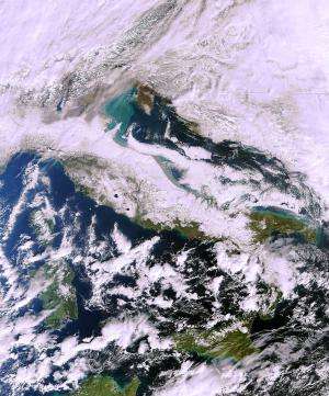
(Phys.org)—Santa Claus may someday need wheels for his sleigh – satellites show a decreasing amount of snow in the Northern Hemisphere.
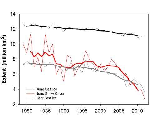
A new analysis of snow cover observed by satellites shows record lows in Eurasia for June each year since 2008. In addition, three of the past five years have seen record low cover in North America.
This is the lowest June snow extent since satellite observations began some 45 years ago. June snow cover is found to be falling much faster than expected from climate models, and is disappearing even quicker than summertime Arctic sea-ice.
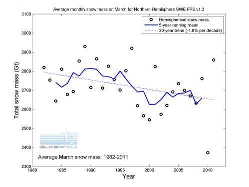
These results, published in Geophysical Research Letters in October and based on snow chart data from the US National Oceanic and Atmospheric Administration (NOAA), are consistent with indications of a decline in monthly-average snow mass, published last year as part of ESA's GlobSnow project.
The results show that the maximum amount of snow across the Northern Hemisphere is slowly falling, while spring snow – particularly at high latitudes – is melting significantly earlier.

GlobSnow produced a long time-series of snow mass from 1979 to 2012, as well as a time-series of snow cover from 1995 to 2012.
The snow mass time-series is the first daily dataset of its kind for the Northern Hemisphere that extends over 30 years and is from satellite sensors measuring Earth's microwave emissions.
Information on snow mass and area is used to monitor and understand changes in seasonal snow cover that are important for the climate and hydrology. This information can only be provided by satellites since they observe large areas on a regular basis.
Along with geophysical applications, reliable data on snow cover can assist decision-makers and policy-makers in creating strategies to adapt to the changes. For this reason, the European Environment Agency has included GlobSnow results in its new "Climate Change, Impacts and Vulnerability in Europe 2012" report.

"The satellite-derived information from GlobSnow on total snow mass provides us with an important indicator that helps us to monitor changes in European and Arctic climate," notes Hans-Martin Fuessel of the European Environment Agency.
A two-year extension of the GlobSnow project is underway, ensuring continuity in producing snow information and improving the data processing. Based on new methods, all data from the first phase of GlobSnow will be reprocessed.
The Envisat satellite was lost in April 2012 so NOAA's satellites are filling the gap until ESA's new Sentinel-3 satellite is launched in 2014.
On 4–5 December, ESA and Eumetsat – the European Organisation for the Exploitation of Meteorological Satellites – will co-host a workshop in Germany to look at existing European satellite snow monitoring capabilities and to set a strategy for their development.
Journal information: Geophysical Research Letters
Provided by European Space Agency


