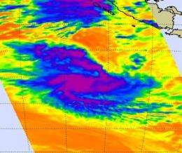
Tropical Storm Anggrek is tightly wrapped in NASA satellite imagery

Bands of strong thunderstorms are wrapping around the center of Tropical Storm Anggrek in the Southern Indian Ocean, according to satellite imagery. NASA's Aqua satellite captured an infrared look at those strong thunderstorms today.
NASA's Aqua satellite passed over Anggrek on Nov. 3 at 07:05 UTC (3:05 a.m. EDT) and the Atmospheric Infrared Sounder (AIRS) instrument onboard captured an infrared image of the cold thunderstorms within the system. The image showed that strong, high thunderstorm cloud tops tightly circled the storm's center. There was also strong convection (rapidly rising air that forms the thunderstorms the power a tropical cyclone) along the southern edge of the low-level center of circulation.
At 0900 UTC (5 a.m. EDT), Tropical Storm Anggrek's maximum sustained winds were near 50 knots (57 mph) with higher gusts. It was about 140 nautical miles south of the Cocos Islands near 14.6 South and 96.9 East. It was moving southwest near 7 mph and is expected to continue moving in that direction.
Anggrek is in an area of moderate vertical wind shear (winds that can weaken and tear apart a tropical cyclone). By the weekend, Anggrek is forecast to steadily weaken and dissipate as it encounters cooler waters and stronger wind shear.
Provided by NASA's Goddard Space Flight Center


