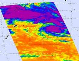
Tropical Storm Oli kicking up waves in south Pacific

Tropical Storm Oli is headed between the islands of Bora Bora and Raratonga in the South Pacific, while maintaining its intensity as a tropical storm. Infrared satellite data from NASA's Aqua satellite reveals that Oli is a large storm, so those islands will experience gusty winds, some moderate to heavy rainfall, and heavy swells along their coasts.
The Atmospheric Infrared Sounder (AIRS) instrument on NASA's Aqua satellite flew over Oli on February 2 at 0041 UTC (Feb. 1 at 7:41 p.m. ET) and captured its extensive area of cloud cover. AIRS measured the temperatures of the clouds and found a large area of high thunderstorm cloud tops around the storm's center, as cold as minus 63 Fahrenheit. Those high, cold cloud tops indicate strong thunderstorms and heavy rainfall.
Infrared satellite imagery also showed that convection (rising air that creates thunderstorms) continues to flare up and dissipate near Oli's low level circulation center. In the satellite image captured earlier today, there is a separate larger band of deeper convection and thunderstorms located to the north of Oli's center. That band has started to elongate from east to west, indicating weakening of the storm is possible in the next day or two.
At 1500 UTC (10 a.m. ET) on February 2, Oli had maximum sustained winds near 52 mph (45 knots) with higher gusts. It was located about 480 nautical miles west of Bora Bora, near 14.8 South and 159.5 West. Oli has tracked eastward at 11 mph (10 knots).
The tropical cyclone warning for Suwarrow has been cancelled, as has the tropical cyclone alert for the Southern Cook Islands. However, a strong wind warning remains in force for the Northern Cook Islands.
Over the next couple of days, Oli is forecast to move southeast and pass between Bora Bora and Tahiti to the north and Raratonga to the south.
Provided by NASA's Goddard Space Flight Center


