This article has been reviewed according to Science X's editorial process and policies. Editors have highlighted the following attributes while ensuring the content's credibility:
fact-checked
peer-reviewed publication
trusted source
proofread
Satellite data assimilation improves forecasts of severe weather

In 2020, a line of severe thunderstorms unleashed powerful winds that caused billions in damages across the Midwest United States. A technique developed by Penn State scientists that incorporates satellite data could improve forecasts—including where the most powerful winds will occur—for similar severe weather events.
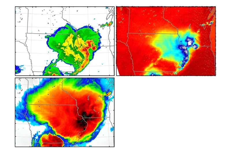
The researchers report in the journal Geophysical Research Letters that adding microwave data collected by low-Earth-orbiting satellites to existing computer weather forecast models produced more accurate forecasts of surface gusts in a case study of the 2020 Midwest Derecho. Derechos are lines of intense thunderstorms notorious for their damaging winds.
"The computer model is able to produce a series of forecasts that consistently emphasize the most powerful storms and strongest wind damage at where it happened," said Yunji Zhang, assistant professor in the Department of Meteorology and Atmospheric Science at Penn State and lead author. "If we have this kind of information in real time, before the events occur, forecasters might be able to pinpoint where the strongest damage is going to happen."
The technique could be especially useful, the scientists said, in areas that lack ground-based weather monitoring infrastructure—like radars traditionally used in weather forecasting. In the study, the researchers only used data available from satellite observations.
"In regions where there are no surface observations, or basically no radar, we show that this combination of satellite observations can generate a decent forecast of severe weather events," Zhang said. "We can probably apply this technique to more regions where there are no radar or dense surface observations. That's the fundamental motivation behind this study."
The research builds on the team's prior work using data assimilation, a statistical method that aims to paint the most accurate picture of current weather conditions. This includes even small changes in the atmosphere as they can lead to large discrepancies in forecasts over time.
In prior work, scientists with Penn State's Center for Advanced Data Assimilation and Predictability Techniques assimilated infrared brightness temperature data from the U.S. Geostationary Operational Environmental Satellite, GOES-16. Brightness temperatures show how much radiation is emitted by objects on Earth and in the atmosphere, and the scientists used infrared brightness temperatures at different frequencies to paint a better picture of atmospheric water vapor and cloud formation.
But infrared sensors only capture what is happening at the cloud tops.
Microwave sensors view an entire vertical column, offering new insight into what is happening underneath clouds after storms have formed, the scientists said.
"Just based on the cloud tops, it's more difficult to infer what the convection of these storms looks like underneath," Zhang said. "So that's one of the benefits of adding in the microwave observations—they can provide information on where the strongest convections are."
By combining assimilated infrared and microwave data in the study of the derecho, the researchers were able to predict surface gust locations and maximum wind values more accurately.
In future work, Zhang said he plans to apply the method to regions that lack the resources and infrastructure to support high-spatiotemporal-resolution weather observations.
"We know that there have been several times in the past several years in West Africa where very strong torrential rainfall events have brought on a lot of precipitation to those countries," Zhang said. "And one thing about these countries is that they are also the places that will likely be impacted most by global warming. So I think if we can use these available satellite observations to provide better forecast for those regions, it will be really beneficial for the people there as well."
Also contributing from Penn State were David Stensrud and Eugene Clothiaux, professors, and Xingchao Chen, assistant professor, all in the Department of Meteorology and Atmospheric Science.
More information: Yunji Zhang et al, Enhancing Severe Weather Prediction With Microwave All‐Sky Radiance Assimilation: The 10 August 2020 Midwest Derecho, Geophysical Research Letters (2024). DOI: 10.1029/2023GL106602
Journal information: Geophysical Research Letters
Provided by Pennsylvania State University


