This article has been reviewed according to Science X's editorial process and policies. Editors have highlighted the following attributes while ensuring the content's credibility:
fact-checked
proofread
Breakthrough in atmospheric analysis: Satellite delivers high spatial resolution ozone profiles

A breakthrough in satellite observations has allowed scientists to obtain high spatial resolution ozone profiles, enhancing our understanding of ozone distribution and its impact on the atmosphere. The research, conducted by the research team led by Cheng Liu and Fei Zhao at the University of Science and Technology of China, utilized data from the Environmental Trace Gases Monitoring Instrument (EMI) on the Gaofen-5 satellite, the first Chinese ultraviolet-visible hyperspectral spectrometer.
Ozone plays a crucial role in the atmosphere, and understanding its vertical distribution is key to comprehending its horizontal and vertical transport, as well as its physical and chemical properties. Satellite observations have emerged as one of the most effective methods for obtaining high-resolution ozone profiles. However, retrieving accurate ozone profiles using the EMI instrument poses unique challenges due to unavailable measurement errors and a low signal-to-noise ratio.
The team developed an algorithm specifically tailored to the characteristics of the EMI instrument, enabling them to retrieve ozone profiles that were in good agreement with ground-based ozonesonde measurements. The algorithm demonstrated an impressive fitting accuracy, with fitting residuals smaller than 0.3% in most regions.
The retrieved ozone profiles showed maximum mean biases of 20% at five latitude bands. Moreover, when EMI averaging kernels were applied, the integrated stratospheric column ozone and tropospheric column ozone exhibited excellent agreement with ozonesonde data.
Remarkably, the research not only unveiled the seasonal variation of surface ozone in the lower layers (0–7.5 km) but also showcased distinct trends in the upper layers (9.7–16.7 km). In March, the ozone peak was found to occur at an altitude of 9.7–16.7 km, highlighting the intricate dynamics of ozone distribution.
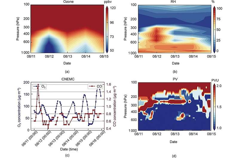
Furthermore, the EMI ozone profiles, alongside potential vorticity and relative humidity data, accurately captured a significant stratospheric intrusion event that occurred in central China from August 11 to 15, 2019. This event shed light on the downward transport mechanism that intensifies surface ozone pollution, as evidenced by an increase in ozone concentration observed by the China National Environmental Monitoring Center (CNEMC).
The Gaofen-5 satellite, launched on May 9, 2018, has played a pivotal role in facilitating these groundbreaking findings. Equipped with the EMI instrument, the satellite has provided invaluable data for monitoring environmental trace gases, as well as housing the directional polarization camera (DPC) and the greenhouse gases monitoring instrument (GMI).
The study utilized an innovative retrieval algorithm, known as OEM, previously employed for TROPOMI ozone profile retrievals, to successfully retrieve ozone profiles from the backscattered radiance observed by the EMI instrument. This methodology has proven to be a game-changer in satellite-based ozone profile measurements.
The researchers open up new avenues in understanding ozone distribution and its impact on Earth's atmosphere. Further advancements in satellite observations and retrieval algorithms will undoubtedly contribute to our knowledge of ozone dynamics, facilitating effective strategies for monitoring and mitigating the impacts of ozone pollution.
The paper is published in the journal Engineering.
More information: Fei Zhao et al, High Spatial Resolution Ozone Profiles Retrieved from the First Chinese Ultraviolet–Visible Hyperspectral Satellite Instrument, Engineering (2023). DOI: 10.1016/j.eng.2023.02.020
Provided by Engineering


