This article has been reviewed according to Science X's editorial process and policies. Editors have highlighted the following attributes while ensuring the content's credibility:
fact-checked
reputable news agency
proofread
Off Alaska coast, research crew peers down, down, down to map deep and remote ocean

For the team aboard the Okeanos Explorer off the coast of Alaska, exploring the mounds and craters of the sea floor along the Aleutian Islands is a chance to surface new knowledge about life in some of the world's deepest and most remote waters.
The National Oceanic and Atmospheric Administration research vessel is on a five-month mission aboard a reconfigured former Navy vessel run by civilians and members of the NOAA Corps. The ship, with a 48-member crew, is outfitted with technology and tools to peer deep into the ocean to gather data to share with onshore researchers in real time. The hope is that this data will then be used to drive future research.
"It's so exciting to go down there and see that it's actually teeming with life," said expedition coordinator Shannon Hoy. "You would never know that unless we were able to go down there and explore."
Using a variety of sonars and two remotely operated vehicles—Deep Discoverer and Serios—researchers aboard the ship are mapping and collecting samples from areas along the Aleutian Trench and Gulf of Alaska. High-resolution cameras that can operate at depths of up to 6,000 meters (19,685 feet) allow researchers to document and immediately share their findings. The ship can also livestream dives to the public.

Many factors, such as depth, speed and sonar capability, influence how much sea floor can be mapped. In 2 to 4 weeks, the Okeanos Explorer can map as much as 50,000 square kilometers (31,069 square miles), Hoy said.
During these dives, Hoy said the team plans to investigate some of the area's cold seep communities—places where gases from under the sea floor rise through cracks and where plants don't rely on photosynthesis for food production.
"We're also going to be looking through the water column to see what interesting animals and fauna that we can see there," she said.
Kasey Cantwell, the ship's operations chief, said the data will help researchers and the public better understand these remote stretches of ocean, including marine life and habitats in the area. That could inform management decisions in fisheries. Data could also help detect hazards and improve nautical charts.

"It's really hard to care for things you don't understand, to love things you don't understand," Cantwell said.
The deep ocean off Alaska's Aleutian Islands is one of the least mapped places in the U.S., partly due to its remoteness. Modern mapping standards have covered just 34% of the sea floor around Alaska, which has one of the nation's largest coastal ecosystems, and only a fraction of that has been seen, according to the expedition's web site.
Closing these gaps is a mission priority, and will help meet a goal of mapping all of the United States' deep waters by 2030 and near-shore waters by 2040, according to Emily Crum, a communications specialist with the National Oceanic and Atmospheric Administration.
But the data collection process is laborious.
Thomas Morrow, a physical scientist on the ship, likened the effort to "walking the length of several city blocks in complete darkness with a tiny flashlight."
-
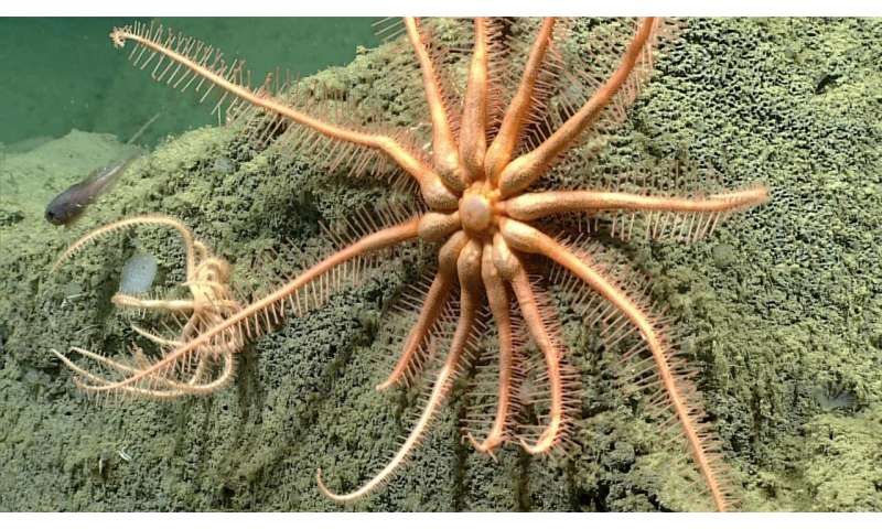
In this photo provided by NOAA Ocean Exploration, a sunstar eats an unknown prey taken from the Okeanos Explorer off the coast of Alaska on July 24, 2023, while exploring the mounds and craters of the sea floor along the Aleutian Islands. The ship, a reconfigured former U.S. Navy vessel run by civilians and members of the NOAA Corps, is specially outfitted with technology and tools needed to access deep into the ocean, and to share that data with the public and on-shore researchers in real-time. Credit: NOAA Ocean Exploration via AP -
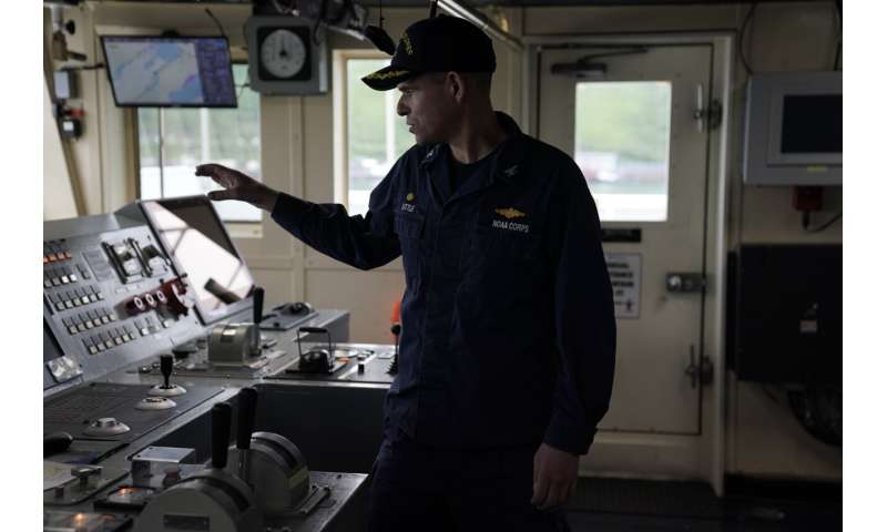
Captain Colin Little explains how he controls the NOAA Okeanos Explorer during a tour, Friday, June 23, 2023, in Kodiak, Alaska. The ship, a reconfigured former U.S. Navy vessel run by civilians and members of the NOAA Corps, is specially outfitted with technology and tools needed to access deep into the ocean, and to share that data with the public and on-shore researchers in real-time. Credit: AP Photo/Joshua A. Bickel -
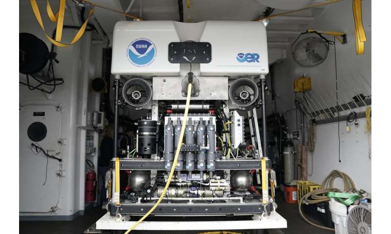
The remotely operated dive vehicle Deep Discoverer is visible aboard the NOAA Okeanos Explorer, Friday, June 23, 2023, in Kodiak, Alaska. The vehicle, which is designed to explore the deep sea and sea floor, can reach depths depths of up to 6,000 meters (19,685 feet). Credit: AP Photo/Joshua A. Bickel -
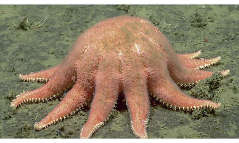
In this photo provided by NOAA Ocean Exploration, a brisingid sea star taken from the Okeanos Explorer off the coast of Alaska on July 19, 2023, while exploring the mounds and craters of the sea floor along the Aleutian Islands. The ship, a reconfigured former U.S. Navy vessel run by civilians and members of the NOAA Corps, is specially outfitted with technology and tools needed to access deep into the ocean, and to share that data with the public and on-shore researchers in real-time. Credit: NOAA Ocean Exploration via AP -
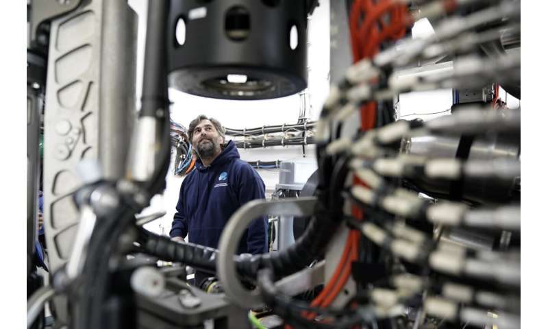
Andy O'Brien explains how he pilots the remotely operated dive vehicle Deep Discoverer during a tour, Friday, June 23, 2023, in Kodiak, Alaska. The ship, a reconfigured former U.S. Navy vessel run by civilians and members of the NOAA Corps, is specially outfitted with technology and tools needed to access deep into the ocean, and to share that data with the public and on-shore researchers in real-time. Credit: AP Photo/Joshua A. Bickel -
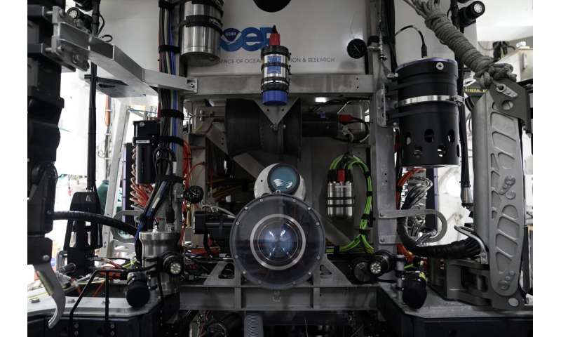
The main camera of the remote operated dive vehicle Deep Discoverer is visible aboard the NOAA Okeanos Explorer, Friday, June 23, 2023, in Kodiak, Alaska. The vehicle, which is designed to explore the deep sea and sea floor, can reach depths depths of up to 6,000 meters (19,685 feet). Credit: AP Photo/Joshua A. Bickel
Nevertheless, all these small looks add up to a better understanding of what lies in the deepest parts of the sea.
In the expedition's first two months, researchers recorded methane seeps and saw a Brisingid sea star at a depth of 2,803 meters (9,200 feet) that had not been documented in the Aleutians before. At least two potential new species have also been discovered.
Earlier this year while on an expedition off the coast of Washington state, researchers aboard the ship documented a jellyfish floating in the deep, and soon had a call from an excited scientist who told them the jellyfish was behaving in ways not seen before.
"The feeling of wonder that sometimes happens in that control room is so palpable," he said.
© 2023 The Associated Press. All rights reserved. This material may not be published, broadcast, rewritten or redistributed without permission.


