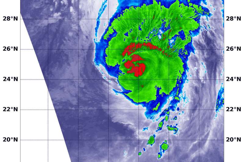
NASA sees Hurricane Walaka battering Papahanaumokuakea Marine National Monument

NASA's Terra satellite analyzed Hurricane Walaka in infrared light as continued to lash the Papahanaumokuakea Marine National Monument in the Central Pacific Ocean.
NOAA's Central Pacific Hurricane Center or CPHC said a Tropical Storm Warning is in effect for Papahanaumokuakea Marine National Monument from Nihoa to French Frigate Shoals to Maro Reef.
Papahānaumokuākea Marine National Monument is the largest contiguous fully protected conservation area under the U.S. flag, and one of the largest marine conservation areas in the world, according to the monument's website. It encompasses 582,578 square miles of the Pacific Ocean (1,508,870 square kilometers) - an area larger than all the country's national parks combined. The name Papahānaumokuākea commemorates the union of two Hawaiian ancestors—Papahānaumoku and Wākea—who gave rise to the Hawaiian Archipelago, the taro plant, and the Hawaiian people.
On Oct. 4 at 4:55 a.m. EDT (0855 UTC) the MODIS instrument or Moderate Resolution Imaging Spectroradiometer aboard NASA's Terra satellite observed Hurricane Walaka and found powerful thunderstorms around the center of circulation. Infrared light that revealed cloud top temperatures were coldest as cold as minus 70 degrees Fahrenheit (minus 56.6 degrees Celsius). NASA research has shown that storms with cloud tops that high in the troposphere and that cold have the capability to generate heavy rain.
At 5 a.m. HST (11 a.m. EDT/1500 UTC), the center of Hurricane Walaka was located near latitude 26.8 degrees north and longitude 166.5 degrees west. That's about 200 miles (325 km) north of the French Frigate Shoals.
Walaka is moving toward the north near 20 mph (31 kph). It is expected to slow its forward speed and turn toward the north-northwest later today and tonight. From Friday through early Saturday morning, Walaka is forecast to move toward the north-northeast at a faster forward speed. Maximum sustained winds are near 110 mph (175 kph) with higher gusts. Gradual weakening is expected to continue during the next couple of days, but Walaka is forecast to remain a hurricane through early Friday morning.
NOAA's CPHC noted "Large surf generated by the broad wind field associated with Walaka will continue to impact most of the Papahanaumokuakea Marine National Monument today."
For updated forecasts, visit: http://www.prh.noaa.gov/cphc
Provided by NASA's Goddard Space Flight Center


