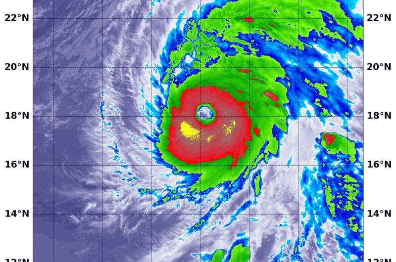
NASA peers into the large clear eye of Hurricane Walaka

An infrared look by NASA's Terra satellite found a ring of intense storms around the wide eye of Hurricane Walaka in the Central Pacific Ocean. Walaka remains a dangerous category 4 hurricane on the Saffir-Simpson Hurricane Wind Scale.
NOAA's Central Pacific Hurricane Center or CPHC cautioned on Oct. 3, "dangerous Hurricane Walaka is intensifying as it moves rapidly north toward the Papahanaumokuakea Marine National Monument and the Johnston Stoll remains in the south quadrant of Walaka."
A Hurricane Warning is in effect for Johnston Atoll, the Papahanaumokuakea Marine National Monument from French Frigate and Shoals to Maro Reef. A Tropical Storm Warning is in effect for Papahanaumokuakea Marine National Monument from Nihoa to French and Frigate Shoals.
On Oct. 3 at 5:45 a.m. EDT (0945 UTC) the Moderate Resolution Imaging Spectroradiometer or MODIS instrument aboard NASA's Terra satellite analyzed cloud top temperatures in infrared light. MODIS found cloud top temperatures of strongest thunderstorms ringed around the wide eye. Those temperatures were as cold as or colder than minus 80 degrees Fahrenheit (minus 62.2 degrees Celsius). They were embedded in a large area that circled the eye where cloud top temperatures were as cold as or colder than minus 70 degrees Fahrenheit (minus 56.6 degrees Celsius). Cloud top temperatures that cold indicate strong storms that have the capability to create heavy rain.
CPHC noted at 2 a.m. HST (8 a.m. EDT/1200 UTC), the center of Hurricane Walaka was located near latitude 18.9 degrees north and longitude 169.8 degrees west. That's about 150 miles (240 km) north of Johnston Island.
Walaka is moving toward the north near 14 mph (23 kph), and it is expected to turn toward the north-northeast with a faster forward motion later today and tonight. Maximum sustained winds are now near 140 mph (225 kph) with higher gusts. Some gradual weakening is possible starting from today or tonight through Thursday, but Walaka is forecast to remain a powerful hurricane when it crosses the Papahanaumokuakea Marine National Monument tonight.
CPHC said, "Walaka is forecast to turn toward the north with a slower forward speed starting Thursday. On this forecast track, the center of Walaka will likely reach the Papahanaumokuakea Marine National Monument tonight."
For updated forecasts, visit: http://www.prh.noaa.gov/cphc
Provided by NASA's Goddard Space Flight Center


