NASA's GPM sees another dangerous typhoon threatening Japan

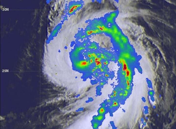
The Global Precipitation Measurement mission or GPM core satellite provided a rainfall and cloud analysis on powerful Typhoon Jongdari as it moves toward Japan. Jongdari follows another powerful typhoon that made landfall in Japan earlier this year.
A tropical cyclone called Prapiroon formed in late June and impacted Japan and South Korea as a typhoon in early July. Record breaking rainfall that began with Prapiroon caused flooding, landslides and many deaths. Today, another called Typhoon Jongdari is located in the northern Pacific Ocean to the southeast of Japan. It is also expected to hit southern Japan and possibly affect South Korea as it is steered toward the northwest from its current position.
Intensifying Typhoon Jongdari had maximum sustained winds estimated at 90 knots (104 mph) when the GPM core observatory satellite passed over it on July 27, 2018 at 0358 UTC (July 26 at 11:58 p.m. EDT). GPM is a joint mission between NASA and the Japan Aerospace Exploration Agency JAXA.
From GPM imagery, it was evident that Jongdari was a large typhoon with extensive areas of heavy precipitation located near the eye and in intense feeder bands. GPM's Microwave Imager (GMI) and Dual-Frequency Precipitation Radar (DPR) data were used in this analysis of JongdarI's precipitation. GPM's data indicated that precipitation was falling at a rate of over 267 mm (10.5 inches) per hour in a band of rain well to the northwest of the typhoon's center.
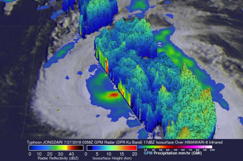
Extreme rain rates were also revealed in storms around Jongdari's eye. The most extreme rainfall rates were measured by DPR in a large feeder band on the eastern side of the typhoon. GPM's radar indicated that rain in those storms was falling at a rate of over 277 mm (10.9 inches) per hour.
At NASA's Goddard Space Flight Center in Greenbelt, Maryland, a 3-D view of Typhoon Jongdari was created using GPM's radar data (DPR Ku Band). The simulated 3-D cross-section portion of this image showed the structure and heights of precipitation within Jongdari. GPM saw that the tallest storms around Typhoon Jongdari were located in the large feeder band on the eastern side of the tropical cyclone. Heights of the tallest storms there were found to reach altitudes above 15.5 km (9.6 miles).

At 11 a.m. EDT (1500 UTC) on July 27, Typhoon Jongdari had maximum sustained winds near 90 knots. It was located near 26.5 degrees north latitude and 143.9 degrees east longitude, about 565 nautical miles south-southeast of Yokosuka, Japan. Jongdari was moving to the northeast at 20 knots (23.02 mph/37 kph) and had maximum sustained winds near 90 knots (103.6 mph/166.7 kph).
The Joint Typhoon Warning Center expects Jongdari will move northeast, later turning north and northwest and intensifying to 105 knots (120.8 mph/194.5 kph) over the next 24 hours, before gradually weakening. The typhoon will move west and pass along the southern coast of Honshu, over Kyushu and westward.
Provided by NASA's Goddard Space Flight Center


