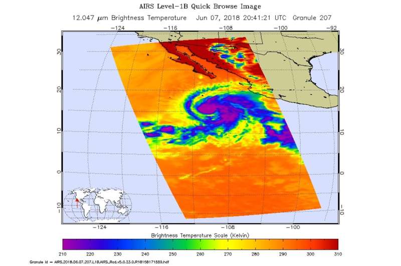
Infrared NASA imagery shows Hurricane Aletta strengthening

When NASA's Aqua satellite passed over Aletta in the Eastern Pacific Ocean it had just become the first hurricane of the season. Infrared imagery showed that Aletta appeared more organized. The National Hurricane Center noted that Aletta could become a Category 4 hurricane later on June 8.
NASA's Aqua satellite passed over Hurricane Aletta on June 7 at 4:41 p.m. EDT (2041 UTC). The Atmospheric Infrared Sounder or AIRS instrument analyzed the storm in infrared light which provides temperature information. Temperature is important when trying to understand how strong storms can be. The higher the cloud tops, the colder and the stronger they are.
AIRS saw coldest cloud top temperatures around the center of circulation and in thick feeder bands from the south and east of the storm's center. Those cloud top temperatures were as cold as minus 63 degrees Fahrenheit (minus 53 degrees Celsius). Storms with cloud top temperatures that cold have the capability to produce heavy rainfall.
The National Hurricane Center (NHC) noted that Aletta became the first hurricane of the east pacific season on June 7 at 5 p.m. EDT.
NHC posted at 5 a.m. EDT (0900 UTC) on June 8, "the eye of Hurricane Aletta was located near latitude 15.8 north and longitude 110.7 west. That's about 475 miles (765 km) west-southwest of Manzanillo, Mexico. Aletta is moving toward the west-northwest near 6 mph (9 kph) and a slow west-northwestward to northwestward motion is expected for the next few days.
Maximum sustained winds remain near 120 mph (195 km/h) with higher gusts. Aletta is a category 3 hurricane on the Saffir-Simpson Hurricane Wind Scale. The hurricane could intensify to category 4 status later today before significant weakening begins this weekend. The estimated minimum central pressure is 957 millibars."
Although Aletta is several hundred miles off-shore from southwestern Mexico, it's a powerful storm and is creating dangerous coastal ocean swells. The National Hurricane Center said on June 8, "Swells generated by Aletta will begin to affect portions of the coast of west-central mainland Mexico and the west coast of Baja California Sur later today and will continue through the weekend. These swells are likely to cause life-threatening surf and rip current conditions.
Provided by NASA's Goddard Space Flight Center


