NASA satellite temperatures reveal a stronger Hurricane Lee

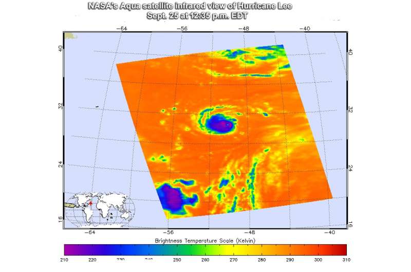
NASA's Aqua satellite peered into Hurricane Lee with infrared light to determine if the storm was intensifying. Infrared data showed cloud top temperatures were getting colder, indicating stronger storms.
The Atmospheric Infrared Sounder or AIRS instrument aboard NASA's Aqua satellite passed over Hurricane Lee on Sept.25 at 12:35 p.m. EDT (1635 UTC) and analyzed the storm in infrared light. Infrared light provides scientists with temperature data and that's important when trying to understand how strong storms can be. The higher the cloud tops, the colder and the stronger they are. So infrared light as that gathered by the AIRS instrument can identify the strongest sides of a tropical cyclone.
At the time Aqua passed overhead, the eye was clear in infrared imagery, and the northwestern side of the storm had a larger area of thunderstorms than the eastern quadrant, suggestive of southeasterly wind shear. Cloud top temperatures in thunderstorms around the eyewall as cold as minus 63 degrees Fahrenheit (minus 53 degrees Celsius). Storms with cloud top temperatures that cold have the capability to produce heavy rainfall.
On Sept. 26, the National Hurricane Center noted that Lee's cloud pattern has continued to become better organized. The eye has cleared out and has warmed to nearly 10 degrees Celsius, and the eye wall cloud tops have cooled to minus 81.4 degrees Fahrenheit (minus 63 degrees Celsius).
At 5 a.m. EDT/AST (0900 UTC) Sept. 26 the center of Hurricane Lee was located near 30.0 degrees north latitude and 52.5 degrees west longitude. That's about 745 miles (1,195 km) east of Bermuda
Lee was moving toward the west near 10 mph (17 kph). Maximum sustained winds are near 100 mph (155 kph) with higher gusts. Some strengthening is expected over the next 24 hours or so. The estimated minimum central pressure is 977 millibars.
The National Hurricane Center forecast calls for a turn toward the west-northwest with some decrease in forward speed early Wednesday, Sept. 27, followed by a turn northwestward by Wednesday evening. Lee is forecast to turn northward and gradually increase in forward speed on Thursday.
For forecast updates on Hurricane Lee, visit: http://www.nhc.noaa.gov
Provided by NASA's Goddard Space Flight Center


