NASA sees development of Tropical Storm Jose

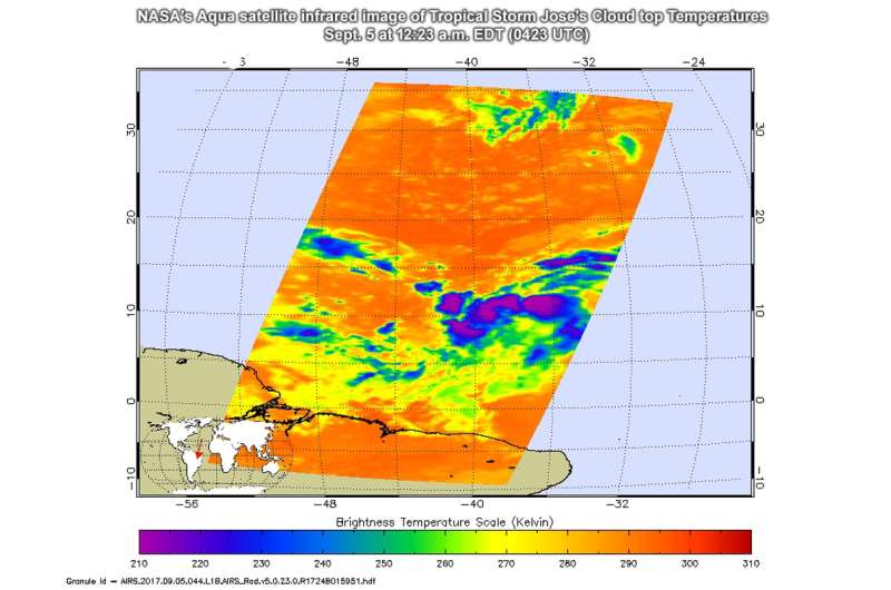
As Tropical Storm Jose was forming in the Eastern Atlantic Ocean, NASA's Aqua satellite analyzed its cloud top temperatures.
The Atmospheric Infrared Sounder or AIRS instrument aboard NASA's Aqua satellite passed over Tropical Storm Jose as it was consolidating. AIRS analyzed the storm in infrared light providing scientists with temperature data and that's important when trying to understand how strong storms can be. The higher the cloud tops, the colder and the stronger they are. So infrared light as that gathered by the AIRS instrument can identify the strongest sides of a tropical cyclone.
NASA's Aqua satellite flew over Jose on Sept. 5 at 12:23 a.m. EDT (0423 UTC) AIRS detected some strong thunderstorms with cloud top temperatures as cold as minus 63 degrees Fahrenheit (minus 53 degrees Celsius). Storms with cloud top temperatures that cold have the capability to produce heavy rainfall. AIRS data and other satellite imagery showed a well-defined though slightly elongated center had formed.
At 11 a.m. EDT (1500 UTC) on Sept. 5, the center of Tropical Storm Jose was located near 12.3 degrees north latitude and 39.1 degrees west longitude. Jose was moving toward the west-northwest near 13 mph (20 kph) and a movement toward the west or west-northwest at a slightly faster rate of forward speed is expected during the next two days. Maximum sustained winds are near 40 mph (65 kph) with higher gusts. Some strengthening is forecast during the next 48 hours and Jose could become a hurricane by Friday.
NHC forecaster Chris Landsea said that Jose should move toward the west or west-northwest for the next three to four days at a slightly faster rate of forward speed as it moves south of the deep-layer Azores-Bermuda high.
For updated forecasts on Jose, visit: http://www.nhc.noaa.gov.
Provided by NASA's Goddard Space Flight Center


