NASA satellite data shows Hurricane Maria's strongest side

NASA's Aqua satellite provided an infrared look at Hurricane Maria's cloud top temperatures and found the coldest cloud tops and strongest storms were facing east of the center and away from the U.S. However, Maria is a large hurricane. On Sept. 26, the National Hurricane Center reported that hurricane-force winds extend outward up to 105 miles (165 km) from the center and tropical-storm-force winds extend outward up to 240 miles (390 km).
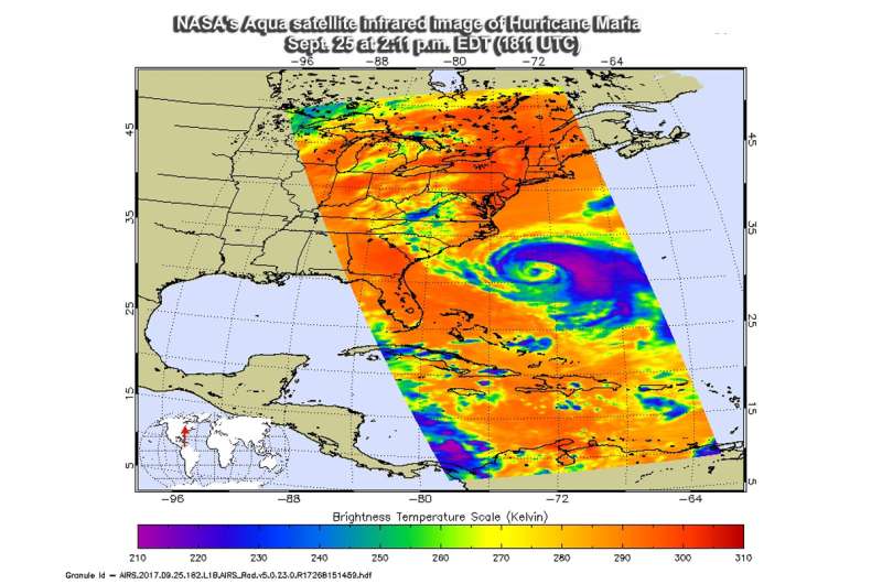
The Atmospheric Infrared Sounder or AIRS instrument aboard NASA's Aqua satellite passed over Hurricane Maria on Sept. 25 at 2:11 p.m. EDT (1811 UTC) and analyzed the storm in infrared light. Infrared light provides scientists with temperature data and that's important when trying to understand how strong storms can be. The higher the cloud tops, the colder and the stronger they are. So infrared light as that gathered by the AIRS instrument can identify the strongest sides of a tropical cyclone. The AIRS image clearly showed the bulk of strong storms in Maria's northeastern quadrant as well as in the storms surrounding the eye.
Cloud top temperatures in thunderstorms around the eyewall as cold as minus 63 degrees Fahrenheit (minus 53 degrees Celsius). Storms with cloud top temperatures that cold have the capability to produce heavy rainfall.
On Sept. 27, the National Hurricane Center noted "the satellite presentation of Maria has continued to slowly degrade over the past 24 hours, as deep convection is now confined to thesoutheastern portion of the circulation."
AIRS data also showed cooler sea surface temperatures, which are expected to help weaken Maria.
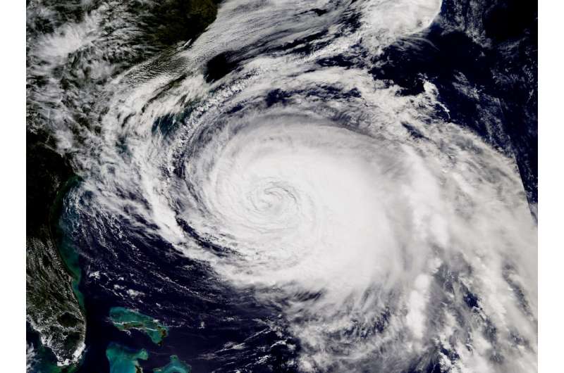
At the same time as the AIRS image, another instrument aboard Aqua called MODIS, or Moderate Resolution Imaging Spectroradiometer took a visible light image of Maria. In the visible image, Maria's eye was covered by high clouds.
Warnings in Effect on September 26, 2017
The National Hurricane Center (NHC) posted a Storm Surge Warning for Ocracoke Inlet to Cape Hatteras, North Carolina. A Tropical Storm Warning is in effect for Bogue Inlet to the North Carolina/Virginia border, and for the Albemarle and Pamlico Sounds.
A Storm Surge Watch is in effect for Cape Lookout to west of Ocracoke Inlet, and north of Cape Hatteras to Duck, North Carolina.
At 11 a.m. EDT on Sept. 26, the National Hurricane Center reported that tropical-storm-force winds nearing North Carolina's Outer Banks. Storm Surge and Tropical Storm Warnings were in place from North Carolina to Virginia.

Status of Hurricane Maria
At 11 a.m. EDT (1500 UTC), the center of Hurricane Maria was located near 33.6 degrees north latitude and 73.1 degrees west longitude. That's about 175 miles (285 km) southeast of Cape Hatteras, North Carolina. The latest minimum central pressure estimated from reconnaissance aircraft data is 971 millibars.
Maria was moving toward the north near 7 mph (11 kph) and NHC said this general motion with some decrease in forward speed is expected, followed by a turn toward the north-northeast on Wednesday, Sept. 27. On the forecast track, the center of Maria will pass east of the coast of North Carolina during the next couple of days.
Maximum sustained winds are near 75 mph (120 kph) with higher gusts. Gradual weakening is forecast during the next couple of days, and Maria is forecast to become a tropical storm within the next day or so.
NHC Key Messages About Maria
The National Hurricane Center shared Key Messages about this large hurricane:
1 Maria is forecast to continue moving northward, paralleling the U.S. east coast for the next 36 hours, and will likely bring some direct impacts to portions of the North Carolina coast throughWednesday where a tropical storm warning is in effect.
2. Storm surge flooding, especially along the sound side of the North Carolina Outer Banks, is expected, and a storm surge warning and watch are in effect for portions of eastern North Carolina.
3. Swells generated by Maria are affecting much of the east coast of the United States. These swells are also affecting Bermuda, the Turks and Caicos Islands, and the Bahamas. These swells are likely to cause life-threatening surf and rip current conditions.
For forecast updates on Hurricane Maria, visit: http://www.nhc.noaa.gov
Provided by NASA's Goddard Space Flight Center


