NASA infrared data targets Maria's strongest side

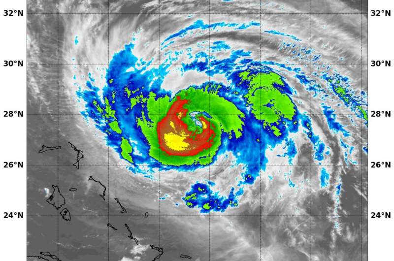
Infrared light provides valuable temperature data to forecasters and cloud top temperatures give clues about highest, coldest, strongest storms within a hurricane. NASA's Aqua satellite provided that data and showed strongest storms were in Hurricane Maria's southwestern quadrant.
On Sept. 24 at 2:35 a.m. EDT (0635 UTC) the Moderate Resolution Imaging Spectroradiometer or MODIS instrument aboard NASA's Aqua satellite analyzed Maria's cloud top temperatures in infrared light. MODIS found cloud top temperatures of strong thunderstorms in Maria's quadrant as cold as or colder than minus 80 degrees Fahrenheit (minus 62.2 Celsius). Cloud top temperatures that cold indicate strong storms that have the capability to create heavy rain.
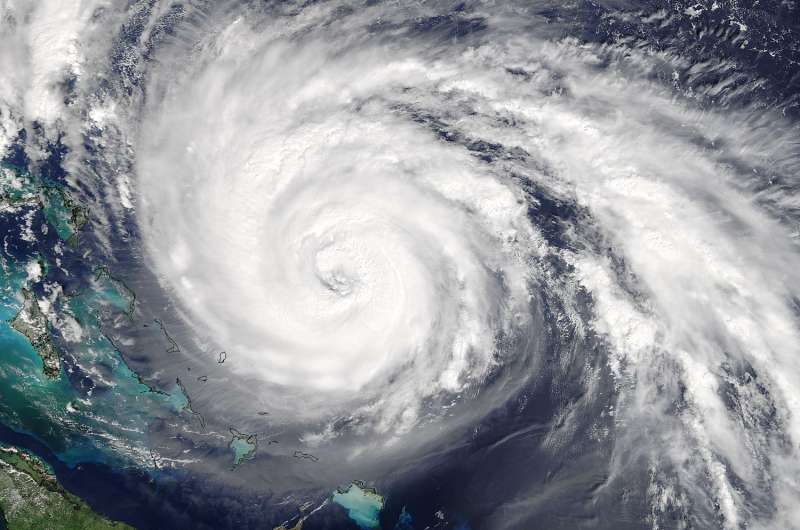
NOAA Hurricane Hunter aircraft showed that Maria now has a 30 nautical mile wide eye and indicated that air pressure within had dropped to 948 millibars. On Sept. 23 at 11:20 a.m. EDT (1520 UTC) the MODIS instrument aboard NASA's Terra satellite captured a visible image of Hurricane Maria and it's 30 nautical mile wide eye, when the storm was located east of the Bahamas.
The National Hurricane Center has noted that Maria has taken slightly more of a westward jog, and cautioned "Interests along the Carolina and Mid-Atlantic coasts should monitor the progress of Maria. Tropical storm or hurricane watches may be needed for a portion of the coast later today, Sunday, Sept. 24."

At 5 a.m. EDT on Sunday, September 24, 2017, the eye of Hurricane Maria was located near 27.9 degrees north latitude and 72.7 degrees west longitude. That's about 530 miles (855 km) south-southeast of Cape Hatteras, North Carolina. Maria was moving toward the north near 9 mph (15 kph), and this general motion is expected to continue through Monday.
Reports from a NOAA Hurricane Hunter aircraft indicate that maximum sustained winds are now near 110 mph (175 kph) with higher gusts. Maria is a category 2 hurricane on the Saffir-Simpson Hurricane Wind Scale. Some fluctuations in intensity are likely during the next day or so. Hurricane-force winds extend outward up to 60 miles (95 km) from the center and tropical-storm-force winds extend outward up to 240 miles (390 km).
Fluctuations in intensity appear likely during the next 24 to 36 hours as Maria remains over warm water and in an environment of light or moderate vertical wind shear. After that time, the hurricane is likely to encounter the colder water left by Hurricane Jose, which should cause a weakening trend.
On the forecast track, the core of Maria will be moving well east of the United States southeast coast during the next two days.
Maria continues to generate dangerous ocean conditions. Swells generated by Maria are increasing along portions of the southeastern United States coast and Bermuda and will be increasing along the Mid-Atlantic coast later today. Swells also continue to affect Puerto Rico, the Virgin Islands, the northern coast of Hispaniola, the Turks and Caicos Islands, and the Bahamas. These swells are likely to cause life-threatening surf and rip current conditions.
Provided by NASA's Goddard Space Flight Center


