NASA finds Hurricane Lee's strength shift

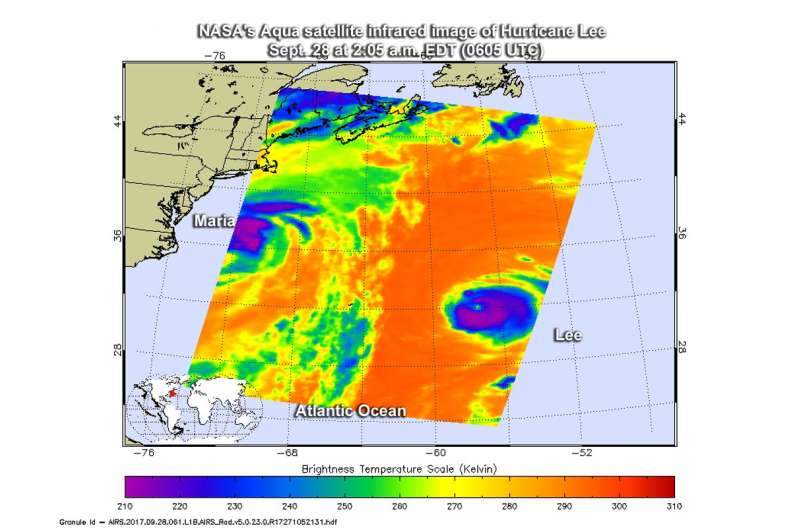
Hurricane Lee began weakening as NASA's Aqua satellite passed overhead and collected temperature information. Satellite data showed that Lee's strongest side was south of its center.
The Atmospheric Infrared Sounder or AIRS instrument aboard NASA's Aqua satellite passed over Hurricane Lee on Sept. 28 at 2:05 a.m. EDT (0605 UTC) and analyzed the storm in infrared light. Infrared light provides temperature data and that's important when trying to understand how strong storms can be. The higher the cloud tops, the colder and the stronger they are.
When Aqua passed over Lee, the AIRS instrument found coldest cloud top temperatures in thunderstorms mostly south of the center. Those temperatures were as cold as minus 63 degrees Fahrenheit (minus 53 degrees Celsius). Storms with cloud top temperatures that cold have the capability to produce heavy rainfall.
On Sept. 26, the National Hurricane Center (NHC) noted that "northerly shear continues to adversely affect the organization of Lee. The central dense overcast has become fairly asymmetric, with most of the cold cloud tops limited to the southern semicircle, and the eye is also losing definition."
Lee is in the Central Atlantic Ocean and far from land areas so there are no watches or warnings in effect. At 11 a.m. EDT (1500 UTC) on Sept. 28, Lee was about 460 miles (745 km) east-northeast of Bermuda, near 33.7 degrees north latitude and 57.0 degrees west longitude. The estimated minimum central pressure is 973 millibars.
Lee was moving toward the north near 12 mph (19 kph) and NHC noted "a turn toward the northeast with an increase in forward speed is expected today and tomorrow morning. The hurricane is forecast to continue accelerating toward the northeast after that."
Lee's maximum sustained winds peaked at 115 mph on Sept. 27. Maximum sustained winds had decreased to near 100 mph (155 kph) with higher gusts. Continued weakening is expected and Lee is forecast to become a tropical storm on Friday, Sept. 29 as wind shear increases and the storm moves over cooler waters.
Provided by NASA's Goddard Space Flight Center


