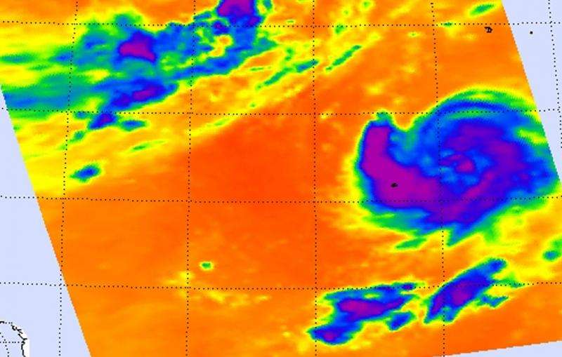
NASA sees Tropical Storm Kilo wrapped halfway around itself

When NASA's Aqua satellite passed over Tropical Storm Kilo early on August 27, infrared imagery showed that bands of thunderstorms wrapped more than halfway around the system.
On August 27, a tropical storm warning was in effect for Johnston Island as Kilo moved closer. Bands of rain and thunderstorms have already been affecting the islands and are expected to continue as the storm moves closer. NOAA's Central Pacific Hurricane Center expects Kilo to bring between 5 to 10 inches of rainfall, with isolated maximum totals near 15 inches.
A false-colored infrared image of Tropical Storm Kilo from August 27 at 00:53 UTC (8:53 p.m. EDT, Aug. 26) showed high, cold, strong thunderstorms with cloud top temperatures in excess of -63F/-53C wrapping halfway around the eastern side of the storm from north to south. The data was made into an image at NASA's Jet Propulsion Laboratory in Pasadena California, using data from the Atmospheric Infrared Sounder or AIRS instrument that flies aboard NASA's Aqua satellite.
AIRS data also showed that the sea surface temperatures around Kilo are near 29 Celsius (84.2 Fahrenheit), warm enough to promote strengthening. Tropical cyclones need sea surface temperatures of at least 26.6C/80F to maintain strength. Warmer sea surface temperatures will assist in strengthening.
At 9 a.m. EDT (5 a.m. HST/1500 UTC) on August 27, 2015 the center of tropical storm kilo was located near latitude 17.8 north and longitude 168.1 west.
Kilo is crawling toward the southwest near 1 mph (2 kph) and is expected to turn west and speed up slowly over August 28 and 29. Maximum sustained winds were near 65 mph (100 kph) and slow strengthening is expected through August 29. The estimated minimum central pressure is 994 millibars.
CPHC indicated that tropical storm conditions are expected on Johnston Island on August 27, as well as increasing large surf especially along north and northeast facing shores and reefs as Kilo approaches. For updates, visit: http://www.prh.noaa.gov/hnl/cphc/.
Kilo is expected to reach hurricane strength after passing Johnston Island and then head north-northwest.
Provided by NASA's Goddard Space Flight Center


