NASA satellite catches Australia's newborn Tropical Storm Edna and stubborn Fletcher

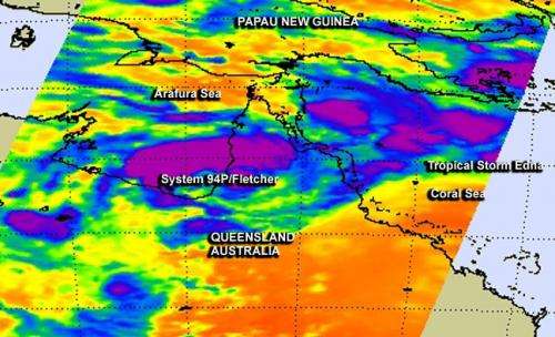
Northeastern Australia has been watching two tropical low pressure areas over the last several days, and NASA's Aqua satellite captured both in one infrared image. Tropical Storm Edna developed on February 4, while Fletcher, known also as System 94P continued to have a medium chance for development.
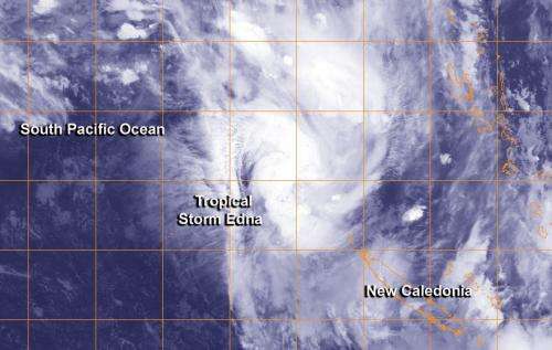
On February 3 at 15:53 UTC/10:53 a.m. EST, NASA's Aqua satellite passed over Queensland, Australia and the AIRS or Atmospheric Infrared Sounder instrument captured infrared data on both storms. System 94P/Fletcher was in the Gulf of Carpentaria and over the Northwest region of Queensland, while newborn Edna formed in the South Pacific Ocean east of Queensland.
System 94P/Fletcher Formation Alert Canceled
On February 4 at 0400 UTC, The Joint Typhoon Warning Center or JTWC canceled their tropical cyclone alert for System 94P/Fletcher. The center of the low was located near 16.5 south latitude and 141.5 east longitude, south of Weipa and about 270 nautical miles/310.7 miles/500 km west-northwest of Cairns, Australia. Weipa is the largest town on the coast of the Gulf of Carpentaria coast in the Cape York Peninsula in Queensland.
The center of the low is over land and satellite imagery has showed that the convection and thunderstorm development has begun to erode. System 94P is also dealing with moderate wind shear and the JTWC noted that computer modeling indicated that the low will remain over land. However, the Australian Bureau of Meteorology or ABM indicates that they believe 94P may move west-southwest on February 5, and go back over southern Gulf of Carpentaria waters, where it could briefly re-intensify. Because of the uncertainty the tropical cyclone alert has been canceled, but satellites and forecasters in both organizations are carefully monitoring the tropical low pressure area.

Regardless of development, ABM notes that the low will drop heavy rainfall over the next couple of days which may lead to flash flooding in the Gulf Country district, mostly near coastal areas. For updates on weather conditions in Queensland from System 94P/Fletcher, visit the Australian Bureau of Meteorology's web page: http://www.bom.gov.au/products/IDQ65002.shtml.
Tropical Storm Edna Moving Toward New Caledonia
System 93P strengthened between February 3 and 4 into Tropical Depression 12P and then Tropical Storm Edna, northwest New Caledonia. By 1500 UTC/10 a.m. EST Edna was about 392 nautical miles northwest of New Caledonia, near 17.2 south latitude and 161.5 east longitude. Edna had maximum sustained winds near 35 knots/40 mph/62 kph. It was moving to the southeast at 19 knots/21.8 mph/35.1 kph.
NASA's AIRS data showed very cold cloud top temperatures in powerful thunderstorms within Edna that have the potential for heavy rainfall. Infrared data also showed that Edna's circulation has consolidated and convection has deepened/strengthened with bands of thunderstorms, mostly north of the center, were wrapping more tightly into the low-level center of circulation.
AIRS data also showed that sea surface temperatures were around 28C/82.4F, warm enough to contribute to strengthening the system. Sea surface temperatures need to be at least 26.6C/80F in order for a tropical cyclone to maintain intensity. Warmer temperatures than that can help in increased evaporation with the formation of thunderstorms that make up a tropical cyclone. However, as Edna continues tracking southward, the storm will run into cooler sea surface temperatures that will squelch any significant intensification.
Provided by NASA's Goddard Space Flight Center


