NASA gets two views of Tropical Cyclone Dylan making landfall in Australia

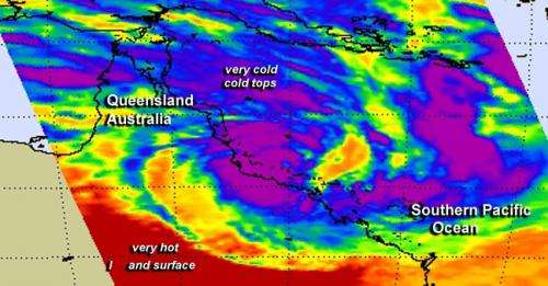
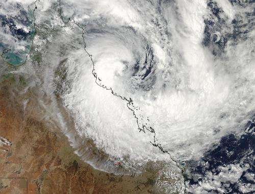
NASA's Aqua satellite passed over Tropical Cyclone Dylan and captured both visible and infrared imagery of the storm as it began landfalling. The visible image showed the extent of the storm, while the infrared data looked at the temperature of cloud tops to determine strong storms were already affecting the coast. The southwestern side of the storm had already started to make landfall in Queensland.
Two instruments that fly aboard NASA's Aqua satellite were working to gather data on Tropical Storm Dylan. The MODIS instrument or Moderate Resolution Imaging Spectroradiometer took a visible picture of the storm, and the AIRS instrument or Atmospheric Infrared Sounder read temperature data using infrared light.
NASA's MODIS instrument captured a visible image of Tropical Cyclone Dylan approaching Queensland, Australia on January 30 at 3:50 UTC. The MODIS image showed a concentration of strong thunderstorms in the center of circulation with a wide and large band of thunderstorms wrapping into the center from the south. The AIRS instrument aboard Aqua captured infrared data three minutes before MODIS gathered the visible data. AIRS showed some of the thunderstorms moving on-shore in eastern Queensland had high cloud tops where temperatures exceeded -63F/-52C. When temperatures of that level are detected, NASA research shows those thunderstorms have the capability of dropping heavy rainfall.
Heavy rainfall, flash flooding, storm surge and gusty winds are all threats to Queensland as Dylan moves closer. A Cyclone Warning posted by the Australian Bureau of Meteorology or ABM remains in effect on January 30 and 31 for coastal and island communities from Cardwell to St. Lawrence extending to adjacent inland areas, including Collinsville.
At 1500 UTC/10:00 a.m. EST on January 30/1 a.m. on Jan. 31 local time (Brisbane, Australia) Tropical Cyclone Dylan had maximum sustained winds near 55 knots/63.2 mph/101.9 kph. It was 178 nautical miles/204.8 miles/329.7 km southeast of Cairns, Queensland, Australia and moving south at 6 knots/6.9 mph/11.1 kph.

ABM noted that Tropical Cyclone Dylan is expected to cross the coast between Ayr and Bowen on Friday morning, January 31 (local time) around sunrise. For the full warning from ABM, visit: http://www.bom.gov.au/cgi-bin/wrap_fwo.pl?IDQ20023.txt
After landfall, Dylan is expected to dissipate within one day. Meanwhile, residents in Dylan's path are facing heavy rains, flash flooding, tropical-storm-force winds and storm surge.
Provided by NASA's Goddard Space Flight Center


