TRMM satellite sees new Tropical Depression forming near Australia's Kimberly coast

Low pressure System 98S appears ripe to form into Tropical Cyclone 05S as NASA satellite imagery is showing some hot towering clouds in the storm and heaviest rains south of the center. System 98S is expected to become a tropical depression on Saturday, December 28, and alerts are already in effect.
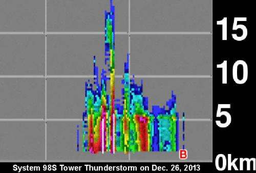
NASA and the Japan Aerospace and Exploration Agency's Tropical Rainfall Measuring Mission or TRMM satellite passed over developing System 98S on December 26 at 1140 UTC/6:40 a.m. EST and noticed a "hot tower" thunderstorm reaching heights of about 17 km/10.5 miles.
A "hot tower" is a tall cumulonimbus cloud that reaches at least to the top of the troposphere, the lowest layer of the atmosphere. It extends approximately 9 miles/14.5 km high in the tropics. These towers are called "hot" because they rise to such altitude due to the large amount of latent heat. Water vapor releases this latent heat as it condenses into liquid. NASA research shows that a tropical cyclone with a hot tower in its eye wall was twice as likely to intensify within six or more hours, than a cyclone that lacked a hot tower.
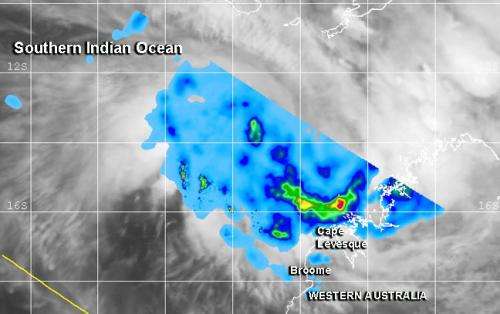
When TRMM passed over System 98S again on December 27 at 1222 UTC/7:22 a.m. EST, it observed heavy rainfall occurring falling at a rate of 1.4 inches/35.5 mm per hour. The heaviest rainfall appeared in a band of thunderstorms south of the center of circulation.
According to the Australian Bureau of Meteorology or ABM, System 98S was 250 nautical miles north-northwest of Broome (located along the Kimberly coast), Australia. System 98S is centered near 14.1 south and 120.9 east according to an interpretation of MTSAT-2 satellite imagery, conducted at the Joint Typhoon Warning Center. Maximum sustained winds are between 25 and 30 knots/28.7 to 34.5 mph/ 46.3 to 55.5 kph.

System 98S is expected to develop into Tropical Cyclone 05S on Saturday as it moves southwest, roughly parallel to the Kimberly coast of northwestern Australia.
Satellite imagery shows that strong convection and thunderstorms are building over the large low-level circulation center. Microwave imagery from a NOAA-19 polar orbiting satellite showed improved strong bands of thunderstorms over the southern quadrant of the storm and wrapping into the center. Low wind shear and warm sea surface temperatures are expected to assist System 98S in development.
ABM issued a Blue Alert for residents in or near coastal areas between Cape Leveque and Broome. Those areas can expect gusty winds as high as 100 kilometers/62.1 miles per hour on Saturday, December 28 and extend further southwest to De Grey by Sunday morning, December 29. Heavy rain is expected on Saturday in coastal areas of the Kimberley north of Broome. As System 98S organizes and moves it is expected to bring heavy rainfall and gusty winds on Sunday into Monday from Port Hedland to Mardie and Karratha. For updated warnings and watches, visit the ABM page: http://www.bom.gov.au/cyclone/index.shtml
Provided by NASA's Goddard Space Flight Center


