NASA satellites get double coverage on newborn Tropical Cyclone Amara

System 93S strengthened into the third tropical depression of the Southern Indian Ocean cyclone season, which quickly became a tropical storm named Amara. NASA's TRMM and Aqua satellites flew overhead shortly after formation and provided visible and rainfall data on the intensifying storm.
Amara's maximum sustained winds were near 35 knots/40 mph/62 kph on December 17 at 0900 UTC/4 a.m. EST. Amara was located near 15.6 south latitude and 72.0 east longitude, about 500 nautical miles/575.4 miles/926 km south of Diego Garcia. Amara is crawling to the northwest at 1 knot/1.1 mph/1.8 kph, because it is moving between two sub-tropical ridges (elongated areas) of high pressure. The storm's course is forecast to change, however, as a new steering influence comes into play.
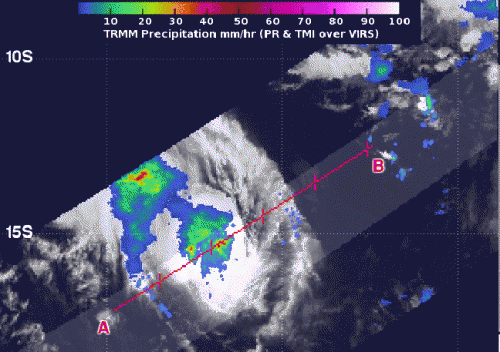
NASA's Tropical Rainfall Measuring Mission or TRMM satellite captured data on rainfall rates occurring in Tropical Cyclone Amara on Dec. 17 at 05:52 UTC/12:52 a.m. EST. TRMM saw heavy rain occurring around the center and northwestern quadrant of the tropical storm. Rainfall rates in those areas topped 50 mm/2 inches per hour.
Over two hours later, NASA's Aqua satellite passed over the storm from its orbit in space. The Moderate Resolution Imaging Spectroradiometer or MODIS instrument captured a visible image of newborn Tropical Cyclone Amara at 08:20 UTC/3:20 a.m. EST that revealed the storm had good circulation.

Forecasters at the Joint Typhoon Warning Center or JTWC noted that the banding structure of thunderstorms around the system remains tightly curved, while the 35-knot/40 mph/62 kph winds are concentrated in the northeast quadrant.
In four days, by December 21, a strong mid-latitude trough, or elongated area of low pressure is expected to pass south of the cyclone and slow it down and cause it to dip toward the southwest. The Joint Typhoon Warning Center expects that Tropical Cyclone Amara will continue to strengthen over the next 5 days reaching hurricane-strength by December 22 as it nears La Reunion Island. Residents of La Reunion Island should closely monitor the progress of Tropical Cyclone Amara.
Provided by NASA's Goddard Space Flight Center


