NASA's TRMM satellite examines Atlantic's Tropical Storm Jerry

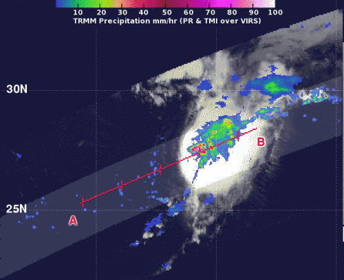
Tropical Depression 11 formed in the central Atlantic Ocean and NASA's TRMM satellite passed overhead and gathered information and identified a "hot tower" that indicated it would strengthen. The depression became Tropical Storm Jerry on Sept. 30 at 10:30 a.m. EDT.
The eleventh Atlantic tropical depression formed around 11 p.m. EDT on Saturday, Sept. 28, about 960 miles/1,540 km east-northeast of the Leeward Islands and was moving north at 9 mph.
When NASA's TRMM or Tropical Rainfall Measuring Mission satellite flew over Tropical Depression 11 on Sept. 30 at 09:28 UTC/5:28 a.m. EDT. TRMM observed a "hot tower" or towering thunderstorm near the center of circulation, where the cloud top exceeded 16 km/9.9 miles high. Rainfall in that storm was also falling at a rate of over 2 inches/50 mm per hour.
A "hot tower" is a tall cumulonimbus cloud that reaches at least to the top of the troposphere, the lowest layer of the atmosphere. It extends approximately nine miles (14.5 km) high in the tropics. The hot towers in Tropical Depression 11 were reaching heights of 16 km/9.9 miles high around the depression's center. These towers are called "hot" because they rise to such altitude due to the large amount of latent heat. Water vapor releases this latent heat as it condenses into liquid. NASA research shows that a tropical cyclone with a hot tower in its eye wall was twice as likely to intensify within six or more hours, than a cyclone that lacked a hot tower. Those hot towers also drop heavy rainfall.
By 10:30 a.m. EDT just 5 hours after NASA's TRMM satellite spotted the "hot tower" in Tropical Depression 11, it strengthened into Tropical Storm Jerry. Jerry had maximum sustained winds near 40 mph/65 kph. It was moving to the east at 7 mph/11 kph and is expected to move slowly and erratically over the next several days. Jerry was centered about 1,200 miles/1,935 km east-southeast of Bermuda. It had a minimum central pressure of 1008 millibars.
Provided by NASA's Goddard Space Flight Center


