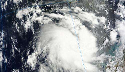
NASA sees Tropical Cyclone Alessia form, threaten western Australia

The low pressure area previously known as System 90S has continued organizing and consolidating and infrared data from NASA's Aqua satellite helped confirm its strengthening into Cyclone Alessia in the Southern Indian Ocean. Alessia formed off of Western Australia's Kimberley coast and the first Cyclone Warnings and Watches of the season are now in effect.
The Moderate Resolution Imaging Spectroradiometer instrument called MODIS that flies aboard NASA's Terra satellite captured a visible image of newly-developed Tropical Cyclone Alessia on Nov. 22 at 02:20 UTC/Nov. 21 at 9:20 p.m. EST. The image showed good circulation and bands of thunderstorms wrapping around the center of circulation from the east and west. Even multispectral satellite imagery showed that the bands of thunderstorms had become more tightly wrapped around the storm's center.
On November 22 at 0900 UTC/4 a.m. EST, Tropical Cyclone Alessia was located about 237 nautical miles/ 272.7 miles/438.9 km northwest of Broome, Australia, near 14.5 south latitude and 120.1 east longitude. Cyclone Alessia had maximum sustained winds near 35 knots/40 mph/62 kph. Alessia was moving to the east-southeast at 14 knots/16.1 mph/25.9 kph toward Western Australia. Forecasters are expecting Alessia to move in a more easterly direction toward Darwin.
Warnings and watches are already in effect for Western Australia. A Cyclone Warning is in effect from Cockatoo Island to Wyndham, and a Cyclone Watch is in effect from coastal areas from Wyndham to Cape Hotham.
According to the bulletin from the Australian Bureau of Meteorology or ABM, gales may develop along the northern Kimberley coast on November 23 as Alessia approaches the coast. The tropical cyclone is expected to brush the northern Kimberley coast and weaken as it approaches the west coast of the Top End on Sunday, November 24. Forecasters at the ABM expect rainfall to be limited to coastal areas. For updated warnings and watches, visit ABM's website at: http://www.bom.gov.au/wa/warnings/.
The Joint Typhoon Warning Center or JTWC forecasters expect Alessia to strengthen before making landfall near Darwin in the next couple of days. The JWTC noted that after Alessia makes landfall it will move across the swampy terrain of northern Australia just south of Darwin and should dissipate in five days (by November 27).
Provided by NASA's Goddard Space Flight Center


