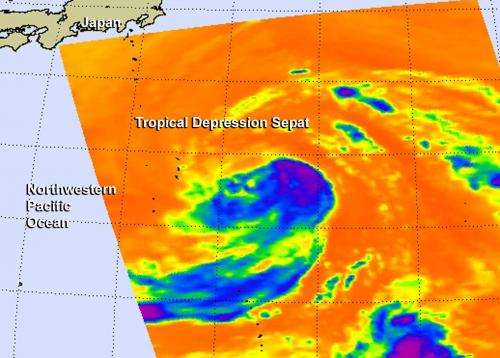
Infrared NASA imagery shows some strength in Tropical Depression Sepat

Tropical Depression Sepat formed in the northwestern Pacific Ocean and NASA's Aqua satellite captured infrared data on the storm, revealing some strong thunderstorms.
Tropical Depression Sepat, the twenty-first tropical depression in the northwestern Pacific Ocean, formed on Sept. 30. NASA's Aqua satellite passed over Sepat on Sept. 30 at 03:23 UTC/Sept. 29 at 11:23 p.m. EDT. As Aqua passed overhead, that Atmospheric Infrared Sounder or AIRS instrument that flies aboard Aqua looked at the storm in infrared light. The AIRS data showed some cold cloud tops of thunderstorms near the center of circulation that were as cold as -63F/-52C indicating some strength in the system.
Satellite imagery also showed that the low-level center remained tightly wrapped, despite weak convective (rising air that forms the thunderstorms that make up a tropical cyclone) organization. Sepat, however is battling moderate wind shear and is expected to track over a pool of cooler waters north of the islands of Iwo To, Japan, which is expected to hinder its development.
On Sept. 30 at 1500 UTC/11 a.m. EDT Tropical Depression Sepat had maximum sustained winds near 30 knots/34.5 mph/55.5 kph. It was centered near 28.3 north and 143.3 east, about 485 nautical miles south-southeast of Yokosuka, Japan. It was moving to the northwest, but is expected to turn to the northeast. For additional information, visit the Joint Typhoon Warning Center website at: http://www.usno.navy.mil/JTWC/
The Joint Typhoon Warning Center or JTWC expects Sepat to briefly strengthen into a tropical storm on Oct. 1 before weakening again to a depression and becoming extra-tropical as it parallels Japan's east coast on a northeastern track. The JTWC expects Sepat's western edge to graze eastern coastal Japan as it moves into the northern reaches of the northwestern Pacific Ocean.
Provided by NASA's Goddard Space Flight Center


