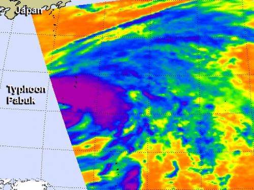
Infrared NASA image shows strength in Typhoon Pabuk's eastern side

Typhoon Pabuk continued to strengthen as it moved north through the northwestern Pacific Ocean on Sept. 23, and NASA's Aqua satellite captured an infrared image of the storm. The NASA image showed powerful thunderstorms east of the storm's center.
On Sept. 23 at 3:17 UTC/Sept. 22 at 11:17 p.m. EDT NASA's Aqua satellite passed over Typhoon Pabuk in the northwestern Pacific Ocean and the Atmospheric Infrared Sounder or AIRS instrument captured an infrared image. The AIRS image showed very high, powerful storms with very cold cloud top temperatures wrapped around the eastern side of the storm. Cloud top temperatures were colder than -63F/-52C, and were likely dropping heavy rainfall.
On Sept. 23, Pabuk's center passed near Iwo To and continued tracking to northwest toward Japan. Just after passing Iwo To, Pabuk intensified from a tropical storm to a typhoon. At 1500 UTC/11 a.m. EDT, Typhoon Pabuk's maximum sustained winds had increased to 65 knots/75 mph/120 kph. Typhoon Pabuk was located just 41 nautical miles northwest of Iwo To, Japan near 25.5 north and 140.4 east. Pabuk is moving to the north-northwest at 5 knots/5.7 mph/9.26 kph.
After passing Iwo To, infrared satellite data showed that Pabuk had maintained form, and in fact had wrapped tighter around the broad and ragged low level circulation center. Pabuk is expected to turn to the northeast, speed up and become extra-tropical in a couple of days as it moves parallel to the eastern coast of Japan, while remaining far at sea. Pabuk may bring rain and gusty winds to east central Japan, including Tokyo on Sept. 25 and Sept. 26 on its journey northeast through the northern Pacific.
Provided by NASA's Goddard Space Flight Center


