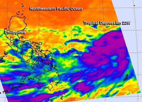
NASA sees tropical depression 22W taking a northern route in northwestern Pacific

The twenty-first and twenty-second tropical depressions of the northwestern Pacific Ocean formed on Sept. 30 and while one is headed to the northeast, the other is headed to the northwest.
Tropical Depression 21W also known as Sepat is forecast to turn to the northeast and parallel the coast of eastern Japan, while staying far off-shore. Tropical Depression 22W, however, is taking a different route and heading to the northwest.
The Atmospheric Infrared Sounder or AIRS instrument that flies aboard NASA's Aqua satellite gathered infrared data on Sept. 30 at 04:59 UTC/12:59 a.m. EDT when it passed over the depression. Some of the thunderstorms in the northern and southern quadrant showed deep/strong convection (rising air that form thunderstorms that make up tropical cyclones).
Satellite data on Sept. 30 showed that the low-level circulation center is consolidating and that banding of thunderstorms were strengthening and organizing along the northern and southern quadrants were starting to wrap tighter into the low-level center.
On Sept. 30 at 1200 UTC/8 a.m. EDT, maximum sustained winds were near 30 knots/34.5 mph/55.5 kph. TD 22W was centered near 28.3 north and 143.3. east, about 485 nautical miles south-southeast of Yokosuka, Japan and 398 nautical miles north-northwest of Koror, Palau. TD22W was moving to the northwest at 15 knots/17.2 mph/27.7 kph. For additional updates, visit: http://www.usno.navy.mil/JTWC/.
The Joint Typhoon Warning Center noted that Tropical Depression 22W will be dealing with favorable environmental conditions over the next several days: good outflow, low vertical wind shear and warm sea surface temperatures. All of those factors will allow the depression to strengthen into a typhoon in the next two days on its trek north.
In three days, a mid-latitude trough of low pressure is expected to move over Japan which will allow a subtropical ridge (elongated area) of high pressure to develop south of Japan and push the depression to the northwest.
Provided by NASA's Goddard Space Flight Center


