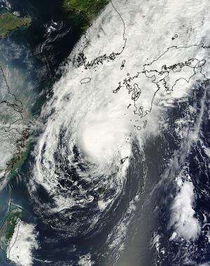
NASA satellite sees Tropical Storm Toraji's concentrated center approaching Japan

A visible image of Tropical Storm Toraji was captured on Sept. 3 at 02:10 UTC/Sept. 2 at 10:10 p.m. is it continued moving north past eastern China and approached southern Japan. The image was taken by the Moderate Resolution Imaging Spectroradiometer or MODIS instrument that flies aboard NASA's Terra satellite. The image showed strong thunderstorms wrapped around the center of the tropical storm. Bands of thunderstorms wrapping into the center from the north extended over Kyushu. Kyushu is the third largest island of Japan and is farthest southwest of Japan's four main islands.
At 1500 UTC/11 a.m. EDT on Monday, Sept. 2, Toraji had maximum sustained winds near 35 knots/40 mph/64 kph, so it was a minimal tropical storm. It was located about 100 miles northwest of Kadena Air Base, Okinawa, near 27.7 north and 126.5 west. Toraji was generating 13-foot/3.9-meter-high seas. That day, infrared satellite data from the MODIS instrument aboard NASA's Aqua satellite showed strong bands of thunderstorms wrapping around the southeastern and eastern quadrant of the storm, and spinning into the low-level center of circulation. Aqua passed over Toraji on Sept. 2 at 1328 UTC/9:28 a.m. EDT.
By Monday, Sept. 3 at 1500 UTC/11 a.m. EDT, Toraji's maximum sustained winds increased to 50 knots/57.5 mph/92.6 kph. The strongest winds are in the northeastern quadrant of the storm. Toraji moved closed to Kyushu and was centered near 30.5 north and 129.3 east, about 172 nautical miles/198 miles/318 km south-southwest of Sasebo, Japan. Toraji is moving to the northeast at 9 knots/10.3 mph/16.6 kph.
Wind shear has increased from the southwest today, Sept. 3. A deep layered mid-latitude trough (elongated area of low pressure) located over the Yellow Sea has created strong vertical wind shear. Winds are blowing from the southwest at up to 30 knots/34.5 mph/55.5 kph.
Toraji is now expected to make landfall in Kyushu and move back over open waters in the Sea of Japan where it is expected to parallel the western coast of Japan. It is expected to begin interacting with mid-level westerly winds and the Baroclinic Zone and become extra-tropical later today.
According to NOAA, the Baroclinic Zone is a region in which a temperature gradient exists on a constant pressure surface. Baroclinic zones are favored areas for strengthening and weakening systems; barotropic systems, on the other hand, do not exhibit significant changes in intensity. Also, wind shear is characteristic of a baroclinic zone, and wind shear can tear tropical cyclones apart.
Between the increased wind shear from the southwest and the interaction with the land (Kyushu), Tropical Storm Toraji is not expected to intensify before making landfall.
Provided by NASA's Goddard Space Flight Center


