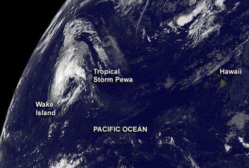
NASA image: Tropical Storm Pewa passing Wake Island

Satellite imagery showed that Tropical Storm Pewa has passed Wake Island on Aug. 21. GOES-West satellite imagery showed Pewa moving farther into the northwestern Pacific.
Tropical Storm Pewa continues trekking through the open waters of the Northwestern Pacific Ocean today, and was captured on NASA satellite imagery.
On Aug. 21 at 1500 UTC, Tropical Storm Pewa had maximum sustained winds near 35 knots/40.2 mph/64.8 kph. Pewa is a small storm, and tropical-storm-force winds extend from the center up to 65 miles. It was centered near 20.9 north latitude and 170.4 east longitude, about 242 nautical miles/278.5 miles/448.2 km east-northeast of Wake Island.
Wake Island is a coral atoll. Its coastline stretches only 12 miles/19 km and it is located just north of the Marshall Islands. Pewa continues moving past Wake Island in a north-northwesterly direction at 12 knots/13.8 mph/22.2 kph.
NOAA's GOES-West satellite captured an image of Pewa on Aug. 21 at 1500 UTC/11 a.m. EDT. GOES-West imagery is created at the NASA GOES Project at NASA Goddard Space Flight Center in Greenbelt, Md. The GOES-West satellite data showed Pewa still has bands of thunderstorms around the center and northern quadrant of the circulation.
Pewa is expected to intensify again while moving northwest. The Joint Typhoon Warning Center forecast indicates that it is expected to become a typhoon over the next five days.
Provided by NASA's Goddard Space Flight Center


