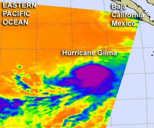
The cold power of Hurricane Gilma revealed by NASA satellite

High, cold cloud tops with bitter cold temperatures are indicators that there's a lot of strength in the uplift of air within a tropical cyclone. NASA's Aqua satellite passed by Hurricane Gilma and saw a concentrated area of very cold cloud tops.
NASA's Aqua satellite passed over Hurricane Gilma on August 9 at 5:53 a.m. EDT. The Atmospheric Infrared Sounder (AIRS) instrument captured an infrared image of the cloud temperatures that showed the strongest storms and heaviest rainfall were wrapped around the storm's center. Cloud top temperatures in that area were as cold as -63 Fahrenheit (-52 Celsius), indicating very strong thunderstorms (a tropical cyclone is made up of hundreds of thunderstorms), with potentially heavy rainfall. The higher a cloud top extends into the atmosphere, the colder it is, and that data is picked up by the AIRS instrument onboard the Aqua satellite.
On August 9, 2012 at 11 a.m. EDT (8 a.m. PDT) Gilma's maximum sustained winds are near 75 mph (120 kmh), down from 80 mph (130 kmh) which makes Gilma a category one hurricane on the Saffir-Simpson Hurricane wind scale. Gilma was far from land and its center was about 715 miles (1,155 km) southwest of the southern tip of Baja California, near latitude 16.2 north and longitude 118.6 west. Gilma is moving toward the west-northwest near 7 mph (11 kmh). Forecasters expect Gilma to turn to the northwest because a ridge of high pressure that has been guiding it is now weakening.
The National Hurricane Center expects Gilma to start weakening over the next day as it moves into an area of cooler waters. AIRS also provides temperature data on sea surface temperatures, and has observed declining temperatures north of Gilma's current location in the Eastern Pacific Ocean. Waters of 80 degrees Fahrenheit (26.6 Celsius) are needed to maintain a tropical cyclone, and Gilma is headed for waters cooler than that over the next couple of days.
Watching Two Other Areas
Forecasters at the National Hurricane Center (NHC) are now watching two additional areas of low pressure to the east of Gilma. The first area is several hundred miles south-southwest of Acapulco, Mexico. The NHC gives this low a meager 10 percent chance of development in the next two days because it appeared more disorganized today on satellite imagery. The second area is a trough (elongated area) of low pressure along Mexico's west coast. That low may interact with Tropical Storm Ernesto which is poised to cross from the Gulf of Mexico into the Pacific. However, because of upper level winds, this low pressure area also has a 10 percent chance of development in the next two days.
Provided by NASA's Goddard Space Flight Center


