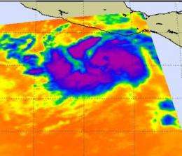
Frigid cloud top temperatures show Hurricane Dora's power

Extremely cold cloud top temperatures in thunderstorms are an indication of the strength they possess, and infrared satellite data from NASA revealed a large area of very cold and powerful thunderstorms around the center of Hurricane Dora.
The Atmospheric Infrared Sounder (AIRS) instrument aboard NASA's Aqua satellite captured an infrared image (false-colored) that revealed strong convection (rapidly rising air that forms thunderstorms) and the strong thunderstorms (purple) around the center of Hurricane Dora. Those areas had cloud-top temperatures as cold as -63F/-52C. Cloud-top temperatures are important because they tell forecasters how high thunderstorms are, and the higher the thunderstorm, the colder the cloud tops and the more powerful the thunderstorms. NASA's Aqua satellite passed over Tropical Storm Dora on July 19 at 20:11 UTC (4:11 p.m. EDT).
At 8 a.m. EDT (5 a.m. PDT) Hurricane Dora was near 14.4 North and 102.3 West. That's about 235 miles (380 km) southwest of Acapulco, Mexico and 250 miles (400 Km) south of Lazaro Cardenas, Mexico. Maximum sustained winds have increased to near 90 mph (140 kmh) with higher gusts. Additional strengthening is forecast during the next 48 hours.
Dora is moving toward the west-northwest near 18 mph (30 kmh) and is expected to gradually turn to the northwest and slow down in the next two days. The National Hurricane Center noted that Dora is expected to move nearly parallel to the coast of southwestern Mexico over the next couple of days.
Dora is expected to brush the southern tip of Baja California on Friday, July 21, so a tropical storm watch is in effect from Lazaro Cardenas to Cabo Corrientes, Mexico. Winds are expected to increase in the watch area tonight, and large ocean swells will affect the coast over the next couple of days.
Provided by NASA's Goddard Space Flight Center


