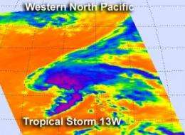
Aqua satellite shows strongest side of Tropical Storm 13W

When NASA's Aqua satellite captured an infrared view of the northwestern Pacific's latest tropical storm, Tropical Storm 13W, the data revealed the bulk of the heavy rainfall on the northern side of the center.
NASA's Aqua satellite passed over Tropical Storm 13W on August 6 at 0205 UTC (Aug. 5 10:05 a.m. EDT). The Atmospheric Infrared Sounder (AIRS) instrument captured an infrared image of the cloud temperatures that showed the strongest storms (purple) and heaviest rainfall north and east of the center of circulation.
Infrared imagery shows temperature and the higher the cloud tops, the colder they are as they reach higher in the troposphere (lowest atmospheric layer). When cloud top temperatures are very cold, it's an indication of strong uplift in the atmosphere. The cloud top temperatures north and east of Tropical Storm 13W's center of this low were near -63 Fahrenheit (-52 Celsius), and indicated powerful uplift and high cloud tops.
At 1500 UTC (11 a.m. EDT) on August 6, Tropical Storm 13W had maximum sustained winds near 45 knots (51.7 mph/83.3 kmh). It was located about 550 nautical miles (632 miles/1019 km) north-northwest of Wake Island near 28.2 North and 162.5 East. It was moving to the north-northwest at 13 knots (15 mph/24 kmh).
Forecasters at the Joint Typhoon Warning Center expect that the tropical storm should maintain intensity while staying at sea over the next several days. Vertical wind shear is expected to decrease and sea surface temperatures are near 26.6 Celsius (80 Fahrenheit), which is needed to maintain a tropical cyclone. The tropical storm is expected to track to the north-northwest and move into drier air, which will prevent further intensification.
Provided by NASA's Goddard Space Flight Center


