Tropical Storm Karina forms in Eastern Pacific near Socorro Island

Socorro Island in the Eastern Pacific received an unwelcome tropical visitor on the morning of August 13 when satellite data confirmed the formation of Tropical Storm Karina.
Karina strengthened from the eleventh tropical depression in the Eastern Pacific. Tropical Depression 11-E formed at 11 p.m. EDT on August 12. Just twelve hours later at 11 a.m. EDT, the depression had become better organized and winds increased to tropical storm strength.
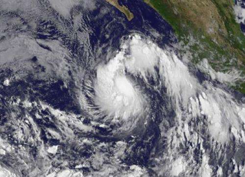
NOAA's GOES-West satellite captured an infrared image of newborn Tropical Storm Karina approaching Socorro Island in the Eastern Pacific on August 13 at 1500 UTC (11 a.m. EDT). The GOES image was created by the NASA/NOAA GOES Project at NASA's Goddard Space Flight Center in Greenbelt, Maryland.
Forecaster Stewart at NOAA's National Hurricane Center noted that deep convection has continued to increase with cloud tops of -80C to -84C (-112F to -119.2F) just west of the low-level center. Infrared data is used to help determine cloud top temperatures. One of NASA's instruments that analyze tropical cyclones is the Atmospheric Infrared Sounder or AIRS instrument that flies aboard NASA's Aqua satellite.
In August 13 at 8 a.m. PDT (11 a.m. EDT/1500 UTC) the center of Tropical Storm Karina was located near latitude 17.2 north and longitude 111.0 west. That's about 110 miles (180 km) south of Socorro Island. Socorro is a small volcanic island and is part of Mexico's Revillagigedo Islands. It is located about 370 miles (600 km) west of mainland Mexico.
Karina's maximum sustained winds were near 40 mph (65 kph) and the National Hurricane Center (NHC) expects strengthening over the next two days as it moves west. The estimated minimum central pressure is 1005 millibars.
Despite the vertical wind shear that is currently affecting the system, it still managed to strengthen and organize into a tropical storm. The National Hurricane Center forecast calls for that wind shear to slowly subside over the next 4 to 5 days while the Karina remains over warm sea surface temperatures of 28-29C, so steady intensification appears likely. NHC expects Karina to reach hurricane strength on August 16.
Provided by NASA's Goddard Space Flight Center


