3 NASA satellites seek clues to Hurricane Julia's rapid intensification
 instrument on NASA's Terra satellite captured a visible image of Hurricane Julia before her rapid intensification. In that image, her eye was cloud-filled. Credit: NASA Goddard/MODIS Rapid Response Team")
Hurricane Julia intensified rapidly overnight and is now a Category 4 hurricane on the Saffir-Simpson Scale and NASA's Aqua, Terra and TRMM satellites captured clues as they passed over her from space.
The Tropical Rainfall Measuring Mission (TRMM) satellite passed over intensifying hurricane Julia during the afternoon of Sept. 14 and captured very heavy rain falling at 1807 UTC (2:07 p.m. EDT). That heavy rainfall was a clue that she would intensify overnight, and today, Sept. 15, she has become a Category Four hurricane on the Saffir-Simpson Scale.
TRMM's Precipitation Radar data showed that concentric rain bands circling Julia's center were dropping heavy rainfall at over 50 mm/hr (~2 inches). TRMM showed that the heaviest rainfall was located in powerful thunderstorms northwest of Julia's center of circulation. Julia's wind speeds increased to 115 knots (~132 mph) by early on Wednesday, September 15 making it a category four hurricane on the Saffir-Simpson scale.
On Sept. 14 at 12:40 UTC (8:40 a.m. EDT) the Moderate Resolution Imaging Spectroradiometer (MODIS) instrument on NASA's Terra satellite captured a visible image of Hurricane Julia before her rapid intensification. In that image, her eye was cloud-filled. Today Julia has "a clear eye structure with impressive cloud top enhancement," according to the National Hurricane Center which is a clear sign that she strengthened since Terra passed by on Sept. 14.
NASA's Aqua satellite flew over Julia today, Sept. 15. The Atmospheric Infrared Sounder (AIRS) instrument onboard captured an infrared image of Julia at 0353 UTC (Sept. 14 at 11:53 p.m. EDT) and did not yet show an eye, which developed later. It did show very strong thunderstorms around Julia's center where cloud heights were as cold as -63 degrees Fahrenheit and heavy rain was falling.
At 11 a.m. EDT today, Sept. 15, Julia's maximum sustained winds were near 135 mph. Julia is a much small storm than the monster that Igor has become. Igor's tropical storm-force winds extend out farther than 275 miles from the center, while Julia's extend 115 miles making her less than half the size of Igor.
-
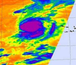
This infrared image of Julia was captured by the AIRS instrument on NASA's Aqua satellite on Sept. 15 at 0353 UTC (Sept. 14 at 11:53 p.m. EDT) and doesn't show an eye, which developed later. It does show very strong thunderstorms (purple) around Julia's center where cloud heights were as cold as -63 degrees Fahrenheit and heavy rain was falling. Credit: NASA/JPL, Ed Olsen -
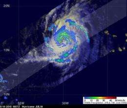
The TRMM satellite noticed concentric rain bands circling Julia's center were dropping heavy rainfall at over 2 inches per hour (red). The heaviest rainfall was located in powerful thunderstorms northwest of Julia's center of circulation. The yellow and green areas indicate moderate rainfall between .78 to 1.57 inches per hour. Credit: NASA/SSAI, Hal Pierce
The outflow from Hurricane Igor and a nearby upper-level low pressure area are combining to produce southerly wind shear over Julia, which is what the National Hurricane Center noted as the reasons her intensity leveled off this morning.
Julia was located about 595 miles west-northwest of the Cape Verde Islands, near latitude 18.2 North and longitude 32.7 West. Her estimated minimum central pressure is 950 millibars. Julia is moving toward the northwest near 15 mph and this general motion is expected to continue over the next day or two.
Julia is expected to maintain its intensity today before slowly weakening later on Sept. 16 from increased southerly wind shear and cooler sea surface temperatures.
Provided by NASA's Goddard Space Flight Center


