August 24, 2013 weblog
Nokia's map data reveals flow of highway life
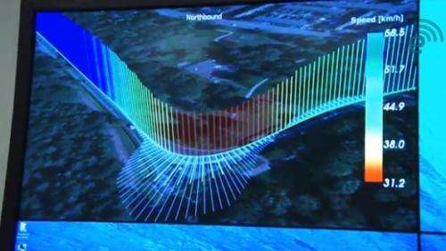
(Phys.org) —Nokia's HERE business is casting bright light on Nokia as a company making use of technologies capable of what it calls "mapping for life," enabling better safety for drivers and better use of information for highway planners. Mapping that is most useful for urban planning takes more than capturing an index of streets and buildings, according to Nokia's experts. Location based tracking and realtime mapping are providing richer models to depend on for safe driving. The HERE team has been showing off its visual analyses of driver behavior. Nokia team members watch how people drive using GPS data from portable devices, smartphone apps, and automobile navigation systems. Nokia's Jane Macfarlane, Head of Research for HERE, recently showed Engadget how Nokia creates mapping data with use of information gathered from opt-in smartphone apps, portable navigation devices, and car navigation systems.
She first showed a video of the San Francisco area and then of Eindhoven in The Netherlands. The Bay Area traffic flow was taken over a 24-hour period. Different vehicle speeds were color-coded—the various colors were used to show fast, medium and slow speeds. The video by doing so makes it easy to visualize traffic changes and hotspots.
In another example, CAN bus data collected from taxis in Eindhoven provided a view of driver behavior around a sharp bend. (CAN bus stands for controller area network which is a vehicle bus standard), monitoring vehicle position, velocity, acceleration, heading and windshield-washer settings. This kind of view could help establish recommended speeds and brake points for the curve, based on the time of day and weather conditions.
Beyond California, Nokia has in the past discussed its work at HERE, saying their aim in studying road traffic data is to help drivers everywhere make sense of the world around them. "HERE offers traffic information in 33 countries for cars, personal navigation devices, smartphones, tablets and websites and we provide maps for four out of five cars with in-dash navigation."
According to HERE, the group aggregates and analyzes traffic data from numerous sources, including a large compilation of both commercial and consumer probe data, a large fixed proprietary sensor network, event-based data collected from government sources, and historical traffic records. "We process billions of GPS probe points per month for our traffic services."
Nokia points out that the data is collected anonymously, using the wisdom of the crowd for enabling real-time updates.
© 2013 Phys.org


