This article has been reviewed according to Science X's editorial process and policies. Editors have highlighted the following attributes while ensuring the content's credibility:
fact-checked
proofread
Researchers create new software for the new European-Japanese Earth observation satellite EarthCARE
 and the Multi-Spectral Imager (MSI) on EarthCARE. Credit: Moritz Haarig, TROPOS; https://amt.copernicus.org/articles/16/5953/2023/")
Preparations for the launch of the new Earth observation satellite EarthCARE (Earth Cloud Aerosol and Radiation Explorer) at the end of May are in full swing. The joint mission of the European Space Agency (ESA) and the Japan Aerospace Exploration Agency (JAXA) will measure clouds, aerosol and radiation more accurately than ever before. This will be made possible by linking four state-of-the-art instruments.
Three so-called processors, which the Leibniz Institute for Tropospheric Research (TROPOS) has developed together with partners, are making an important contribution to the mission. These algorithms have now been described in detail in a special issue of the journal Atmospheric Measurement Techniques.
The new software makes it possible to derive cloud properties from the passive spectrometer (MSI), aerosol and cloud layers from the active, high-spectral-resolution lidar (ATLID) as well as synergetic cloud and aerosol products from both instruments. An aerosol classification model (HETEAC) was developed as the basis for aerosol typing to ensure that these calculations work across the different devices.
EarthCARE will be the first to combine a high-spectral-resolution lidar and a Doppler cloud radar with passive sensors, making it the most complex satellite mission ever launched into space to study aerosol, clouds and their radiative effects. The development of EarthCARE took more than 15 years and cost around 800 million euros.
The satellite offers great opportunities for science: State-of-the-art technology on board provides a variety of data that will improve the accuracy of climate models and support numerical weather prediction.
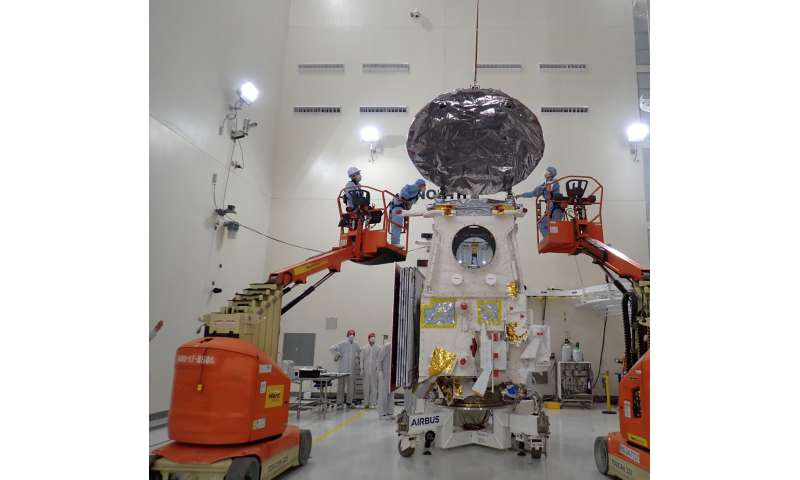
The EarthCARE satellite, which is 17.2 meters long, 2.5 meters wide, 3.5 meters high and weighs around 2,200 kilograms, was assembled by the German prime contractor Airbus in Friedrichshafen, tested extensively together with ESA and then transported by plane to Vandenberg (California, U.S.), where it will be launched into its target orbit at an altitude of 393 kilometers by a Falcon 9 rocket from the US space company SpaceX at the end of May.
 provides information on the vertical structure and internal dynamics of clouds, the atmospheric lidar (purple) provides information on the cloud top and profiles of thin clouds and aerosols, the multispectral imager provides a comprehensive overview of the scene in different wavelengths and the broadband radiometer measures reflected solar radiation and outgoing infrared radiation. Credit: ESA/ATG medialab")
The Earth Cloud Aerosol and Radiation Explorer (EarthCARE) is equipped with four instruments: a Doppler cloud radar, a lidar with high spectral resolution, an imaging spectrometer and a broadband radiometer with three different viewing directions. The instruments will provide synergistic observations of aerosol, clouds, radiation and their interactions with unprecedented accuracy.
One of the goals of the mission is to reconcile the measured and calculated radiative fluxes at the top of the atmosphere for a 100 square kilometer snapshot with an accuracy of 10 Watts per square meter, which would significantly improve knowledge of global radiative forcing.
The EarthCARE data is calculated almost in real time (near real time) using a sophisticated data processing chain. The lidar provides vertical profiles and thus a cross-section of the atmosphere along the satellite's flight path.
From this, the algorithms developed at TROPOS derive the cloud top height and the height of aerosol layers, which can consist, for example, of Saharan dust or smoke from large forest fires. These algorithms are also known as processors in technical jargon and are the software heart of data analysis.
In addition to lidar, the imaging spectrometer makes it possible to characterize the atmosphere using a horizontal, 150 km-wide image of cloud and aerosol properties. The micro- and macrophysical cloud properties, such as the cloud optical thickness, the cloud droplet radius and the cloud top height, are determined using another processor developed at TROPOS.
The third processor developed at TROPOS combines the height-resolved information from the lidar with the horizontal information from the spectrometer in order to obtain an improved three-dimensional image of the atmosphere along the flight path of the earth-orbiting satellite. Aerosol classification in all EarthCARE algorithms is based on the HETEAC model (Hybrid End-to-End Aerosol Classification).
"The HETEAC aerosol classification model developed by TROPOS together with partners plays a central role in the processing of the data because it ensures that the devices speak the same language, so to speak, and that their data provide an uniform overall picture," explains Dr. Ulla Wandinger from TROPOS, who led the development of this model.
But the analysis of the lidar and spectrometer data also includes several decades of know-how in cloud and aerosol observation from TROPOS.
"The retrieval methods developed in our processors will ensure that the quality of the cloud and aerosol data will improve significantly," reports Dr. Anja Hünerbein, who played a key role in the development of the software for the passive spectrometer.
-
Testing and preparing the EarthCARE cloud profile radar for the launch in California. One of the tasks was to open the satellite's 2.5 meter wide radar antenna, which creates the cloud profile. This instrument, provided by the Japan Aerospace Exploration Agency (JAXA), is designed to penetrate clouds and provide detailed insights into their vertical structure, velocity, particle size and distribution, and water content. Credit: European Space Agency - ESA -
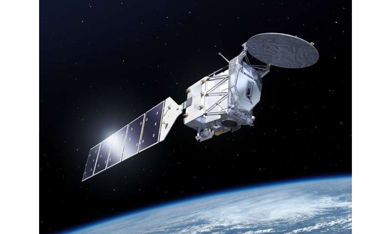
Artistic view of EarthCARE in space. Credit: ESA-P. Carril
Researchers from TROPOS in Leipzig have not only worked on the software, but will also be involved in checking and calibrating the data. This is because careful validation of the measurements is necessary in order to achieve the ambitious scientific goals of the EarthCARE mission.
The European research infrastructure ACTRIS (Aerosol, Clouds and Trace Gases Research Infrastructure) plays a major role in the validation process. The ACTRIS remote sensing stations are ideally equipped for this purpose: The standard equipment, consisting of a high-performance lidar and a sun photometer for aerosol measurements as well as a Doppler radar and a microwave radiometer for cloud measurements, together with the ACTRIS quality assurance concept, enables a detailed review of all EarthCARE aerosol and cloud products.
"Workflows for observation, data processing and the provision of data in near real time have already been developed and extensively tested. For this summer, we are organizing a campaign with over 40 stations that will last several months," says Dr. Holger Baars from TROPOS, who is coordinating the campaign. In addition to the TROPOS stations in Leipzig (Germany), Mindelo (Cabo Verde) and Dushanbe (Tajikistan), many ACTRIS stations throughout Europe will also be involved.
The extensive validation efforts carried out by TROPOS and many international research teams serve to precisely check the developed processors and the measured variables determined with them. Only then will it really be clear how well the properties of aerosol and clouds and their radiative effects can be determined by EarthCARE and how the globally measured data can be used to improve our understanding of the atmosphere.
Europe's new "eye" in space will be able to see the complicated interactions between clouds, aerosol and radiation more clearly and precisely than ever before with the help of the ground stations.
More information: Robin J. Hogan et al, Preface to the special issue "EarthCARE Level 2 algorithms and data products": Editorial in memory of Tobias Wehr, Atmospheric Measurement Techniques (2024). DOI: 10.5194/amt-17-3081-2024
Provided by Leibniz Institute for Tropospheric Research (TROPOS)


