This article has been reviewed according to Science X's editorial process and policies. Editors have highlighted the following attributes while ensuring the content's credibility:
fact-checked
trusted source
proofread
Secondary eyewall formation in upper- and lower-layer vertical wind shear simulated in idealized tropical cyclones

About 80% of intense tropical cyclones (TCs) possess concentric eyewalls—namely, the primary and secondary eyewalls. The intensity of the TC can vary considerably during secondary eyewall formation (SEF) and eyewall replacement, posing a great challenge to predicting TC intensity.
Recently, a research team led by Qingqing Li at Nanjing University of Information Science and Technology investigated the characteristics of SEF in vertical wind shear (VWS)—a variable that measures the differences in direction and velocity between upper- and lower-level winds—at different altitudes. The findings have been published in Atmospheric and Oceanic Science Letters.
"There are many unknowns about the SEF process," says the corresponding author, Qingqing Li, "and we still have a long way to go to explore the corresponding mechanisms."
"Concentric eyewalls mean that two rainfall-rich rings surround the TC eye, and a secondary wind maximum is observed. Sometimes, the secondary wind maximum does not exist, in which case the situation is called fake concentric eyewalls."
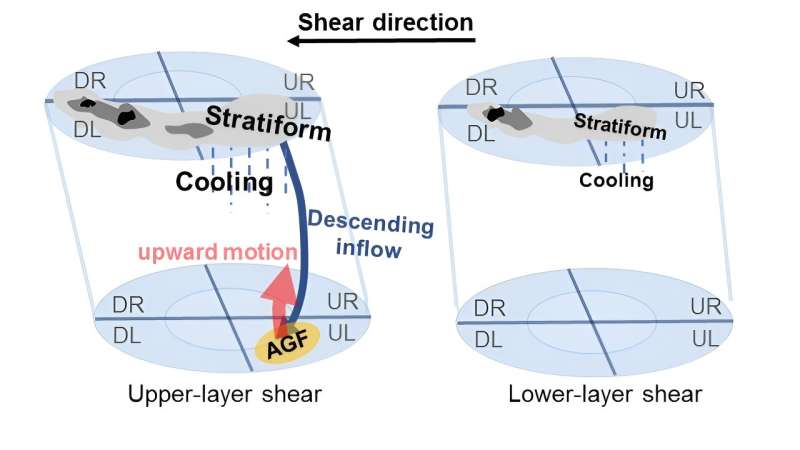
"Several previous studies have pointed out that VWS can produce a principal rainband with stratiform clouds in its downwind sector. Convection, which contributes to the subsequent SEF, can be boosted on the interior side of the stratiform sector. So, VWS can have an important influence on SEF," explains Li.
"We used a high-resolution numerical model to study the characteristics of SEF in upper-layer shear and lower-layer shear," says Li. "Of interest is that SEF was only present in upper-layer VWS at a relatively low shear height, and fake SEF was present in upper-layer VWS at a relatively high shear height and in lower-layer VWS."
"In our simulations, broad stratiform clouds were located in the downwind sector of principal rainbands before the SEF. Meanwhile, active convection was produced on the inner side of the stratiform clouds, leading to the final SEF."
These results deepen our understanding of SEF in shear environments. In future studies, the researchers plan to explore the interactions between VWS at different altitudes and ambient humidity and the associated processes governing SEF.
More information: Yixuan He et al, Secondary eyewall formation in upper- and lower-layer vertical wind shear simulated in idealized tropical cyclones, Atmospheric and Oceanic Science Letters (2024). DOI: 10.1016/j.aosl.2024.100465
Provided by Chinese Academy of Sciences


