This article has been reviewed according to Science X's editorial process and policies. Editors have highlighted the following attributes while ensuring the content's credibility:
fact-checked
peer-reviewed publication
trusted source
proofread
Ancient Sahul's submerged landscapes reveal a mosaic of human habitation

New research conducted by a team of archaeologists and Earth scientists has shed light on the ancient landscapes of Sahul, the Pleistocene (Ice Age) landmass comprising Australia and New Guinea.
The findings, published this week in Quaternary Science Reviews, offer a fascinating glimpse into a previously unrecognized chapter of human history. The article is titled "Sea level rise drowned a vast habitable area of north-western Australia driving long-term cultural change."
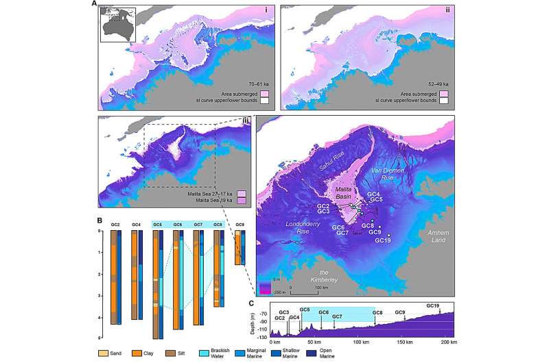
For the majority of the last 65,000 years of human history in Australia, lower sea levels revealed a vast expanse of dry land in the northwest of the continent, connecting the Kimberley and Arnhem Land into a contiguous area.
Through meticulous analysis of high-resolution bathymetric data (ocean floor topography), it has been unveiled that this region, now submerged, existed as an extensive archipelago during Marine Isotope Stage 4 (71,000–59,000 years ago), which remained stable for ~9,000 years
This transformed into a fully exposed shelf in Marine Isotope Stage 2 (29,000–14,000 years ago), featuring an inland sea adjacent to a sizable freshwater lake, encircled by high escarpments cut by deep gorges.
The team's demographic modeling indicates that this now-submerged shelf experienced fluctuating potential carrying capacities through Marine Isotope Stages 4-2, potentially supporting populations ranging from 50,000 to 500,000 people at various times.
However, rapid global sea level rises between 14,500–14,100 years ago (during Meltwater Pulse 1A) and between 12,000 and 9,000 years ago resulted in the rapid inundation of approximately 50% of the Northwest Shelf, causing profound changes in the space of human life spans.
These events likely triggered the retreat of human populations ahead of the encroaching coastline, evident in peaks of occupational intensity at archaeological sites across the Kimberley and Arnhem, and the sudden appearance of distinctive new rock art styles in both regions.
Lead researcher Kasih Norman said, "The presence of this extensive archipelago likely facilitated the successful dispersal of the first maritime explorers from Wallacea—the region of modern-day Indonesia—providing a familiar environment for their adaptation to the vast continent of Sahul."
Furthermore, the study emphasized the critical role that the now-submerged continental margins played in early human expansions.
"The temptation to overlook the continental shelf margins of Late Pleistocene Sahul in discussions of early peopling and expansion risks oversimplification and misunderstanding of this pivotal period in history," added Norman.
The implications of these findings underscored the need to reevaluate the narrative of early human migration and the impact of climate change on ancient populations.
Norman said, "Our demographic modeling showed a peak in population size at the height of the last ice age ~20,000 years ago, when the entire extent of the Northwest Shelf was dry land. This finding has now been supported by new genetic research showing very large populations for the Tiwi Islanders—located just to the east of the study region—at the height of the last glacial period."
As submerged landscapes continued to yield invaluable archaeological insights, the rise of undersea archaeology in Australia contributed to a global understanding of human migration during the Late Pleistocene.
This research marked a significant milestone in understanding the complex interplay between ancient landscapes, human populations and environmental change. Dr. Norman said as exploration and analysis of underwater sites expanded, it promised to unravel more secrets of our shared human history.
More information: Kasih Norman et al, Sea level rise drowned a vast habitable area of north-western Australia driving long-term cultural change, Quaternary Science Reviews (2023). DOI: 10.1016/j.quascirev.2023.108418
Journal information: Quaternary Science Reviews
Provided by Griffith University


