Why was there a super sandstorm in North China this year?

Severe sandstorms reoccurred in the spring of 2021 after absence for more than 10 years in North China. During 14-17 March, the severe sandstorm weather affected a board region of more than 3.8 million square kilometers. The PM10 concentrations in Beijing exceeded 7000 µg m−3, and the visibility was only a few hundred meters, which posed a serious threat to people's health, transportation and ecological civilization.
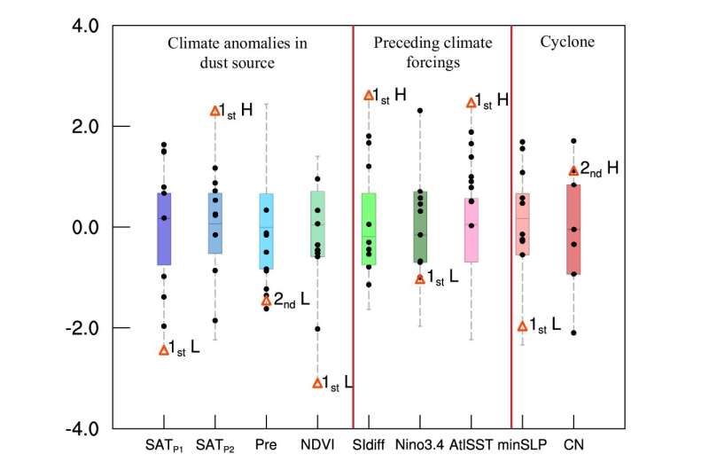
The team led by Prof. Huijun Wang (Nanjing University of Information Science & Technology) found that the surface air temperature (SAT) and underground soil temperatures in the dust source area (around Mongolia) were persistently lower (the lowest from 1979) during early-winter, but persistently higher (the highest from 1979) during late-winter. The cooler temperature resulted in deeper permafrost, and then strong warming led the land surface to thaw and become more loose. Meanwhile, the winter precipitation was the second smallest during the recent decade. Moreover, the surface vegetation coverage reached its worst since 1979. Once strong winds appear, the dust particles will rise with the wind to produce dust or sandstorm.
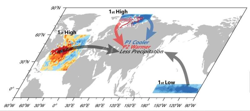
Prof. Zhicong Yin (first author) pointed out it is more important to find preceding climate drivers, that contained efficient prediction information, from the observations and CMIP6 simulations. Decreased November-December Barents and Kara sea ice would increase the local geopotential height and Ural blocking high, and then the anomalous northerlies transported cold air mass to Mongolia in early-winter. However, the positive anomalies of January-February sea ice induced the cold air mass to be trapped over the West Siberian Plain and the East European Plain and resulted in warmer land surface in Mongolia.
La Niña event (cooler east tropical Pacific) and positive sea surface temperature anomalies in northwest Atlantic were found to be the other two external forcing factors. After the La Niña event, the East Asian winter monsoon would strengthen, and the water vapor flux easily diverged around Mongolia and precipitation consequently decreased. Similarly, the warmer Northwest Pacific induced an upper Rossby wave-like train to weaken the Asian polar vortex and strengthen the Ural High, and resulted in reduction of winter precipitation in Mongolia. In summary, the reversal of sea ice anomalies, the La Niña event and the warmer Northwest Atlantic jointly led to the loose and dry surface in Mongolia, i.e., sufficient dust source.

Moreover, the strongest Mongolian cyclone during recent decade formed and developed in 14-15 March 2021. The descending motions with downward transport of westerly momentum dramatically enlarged the surface winds (25 m s-1), which shook and blew the dry and loose land surface. Subsequently, the ascending motions in front of the cyclone lifted the sand particles into the troposphere. With the movement and development of Mongolian cyclone, the cold advection carried large amounts of dust particles to North China. At 09:00 on 15 March, the tropospheric westerly momentums were transported downward to the surface, resulting in large gusts (15 m s-1), thus severe sandstorm happened in North China.
More information: Zhicong Yin et al, Why super sandstorm 2021 in North China, National Science Review (2021). DOI: 10.1093/nsr/nwab165
Provided by Science China Press


