NASA estimates Tropical Depression Imelda's huge Texas rainfall

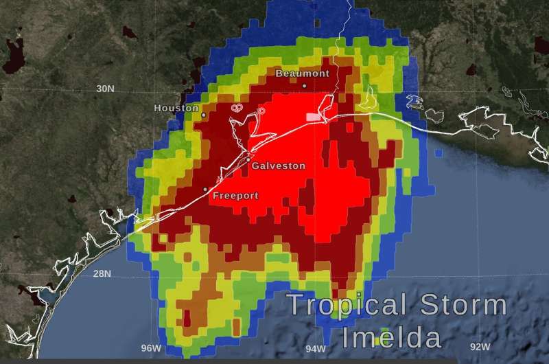
Northeastern Texas has borne the brunt of Tropical Depression Imelda's heavy rainfall and NASA estimated that rainfall with an algorithm that incorporates data from satellites and observations.
By Thursday morning, September 19, Tropical Storm Imelda had dropped over 10 inches of rain over a large area between Houston and Beaumont, Texas. At NASA's Goddard Space Flight Center in Greenbelt, Maryland, a graphic was produced that shows precipitation that fell starting on Tuesday, September 17, the day that Imelda formed as a tropical depression in the Gulf of Mexico, intensified into a tropical storm, and made landfall in Texas, all within a few hours.
The near-realtime rain estimate comes from the NASA's Integrated Multi-satellitE Retrievals for GPM (IMERG) algorithm, which combines observations from a fleet of satellites, in near-realtime, to provide near-global estimates of precipitation every 30 minutes. This satellite-based rain estimate is somewhat coarse in resolution and can miss short-lived, intense storm-cells, but the IMERG algorithm often does captures the large-scale features of storms wherever they form in the world. While the United States is fortunate to have a network of ground radars that can provide higher-resolution precipitation estimates, in other parts of the world, notably over most of the world's oceans, the IMERG rain estimate is an important reference point.
By combining NASA precipitation estimates with other data sources, we can gain a greater understanding of major storms that affect our planet.
NOAA's Storm Prediction Center also reported several preliminary reports of tornadoes on Wednesday evening, September 18.
On September 19 at 5 a.m. EDT, NOAA's National Weather Service Weather Prediction Center (NWS NPC) in College Park, Md. forecast indicated that Imelda's heavy rainfall is expected to continue. Flash flood watches are in effect for parts of eastern Texas and western Louisiana.
The NWS forecasts that Imelda is expected to produce the following rainfall amounts through Friday: Across the Upper Texas Coast into far southeast Texas... an additional 5 to 10 inches with isolated storm totals of 25 to 35 inches are possible. Across portions of southwest Louisiana...an additional 3 to 5 inches with isolated totals of 10 inches are expected. For the rest of east Texas...2 to 4 inches with isolated totals around 8 inches are forecast. These rainfall totals may produce significant to life threatening flash floods.
At 5 a.m. EDT (0900 UTC), the center of Tropical Depression Imelda was located near latitude 31.3 North, longitude 95.5 West. That puts the center of Imelda's circulation about 110 miles (180 km) north of Houston, Texas and about 70 miles (115 km) northeast of College Station, Texas. The depression is moving toward the north-northwest near 5 mph (7 kph) and this motion is expected to continue through today. Maximum sustained winds are near 30 mph (45 kph) with higher gusts. The estimated minimum central pressure is 1009 millibars. A gradual weakening is forecast during the next 24 hours.
Hurricanes are the most powerful weather event on Earth. NASA's expertise in space and scientific exploration contributes to essential services provided to the American people by other federal agencies, such as hurricane weather forecasting.
More information: For more information about NASA's IMERG, visit: https://pmm.nasa.gov/gpm/imerg-global-image
For updated forecasts on Imelda, visit: http://www.nhc.noaa.gov
Provided by NASA's Goddard Space Flight Center


