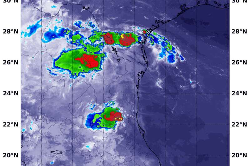
NASA finds a few strong storms left in Fernand's remnants over Northeastern Mexico

Tropical Storm Fernand made landfall in northeastern Mexico and began dissipating. However, infrared imagery from NASA's Aqua satellite shows that there are still fragmented strong storms left in the tropical cyclone's remnants. Those storms have the potential to generate heavy rainfall and there were warnings posted on Sept. 5.
NASA's Aqua satellite used infrared light to analyze the strength of storms in the remnants of Tropical Storm Fernand. Infrared data provides temperature information, and the strongest thunderstorms that reach high into the atmosphere have the coldest cloud top temperatures.
On Sept. 5 at 4:20 a.m. EDT (0820 UTC), the Moderate Imaging Spectroradiometer or MODIS instrument that flies aboard NASA's Aqua satellite found strongest thunderstorms had cloud top temperatures as cold as minus 70 degrees Fahrenheit (minus 56.6 Celsius). Cloud top temperatures that cold indicate strong storms with the potential to generate heavy rainfall.
The Servicio Meteorológico Nacional (SMN) is Mexico's national weather organization. On Sept. 5, SMN issued several warnings for rainfall from Fernand's remnants. SMN forecasters expect rainfall will total up to 15 inches over northeastern Mexico. In Tamaulipas less than one additional inch is expected. However, in central and southern Nuevo Leon, another 3 to 6 inches is expected. In northern Nuevo Leon and southern Coahuila, 2 to 5 inches are forecasts, and south Texas and the lower Texas coast can expect between 1 to 2 inches, totalling 6 inches in that area.
NOAA's National Hurricane Center (NHC) issued the final advisory on the remnants of Fernand at 0300 UTC on Sept. 5 (11 p.m. EDT on Sept. 4). At that time, the remnants were centered near 23.0 degrees north latitude and 99.0 degrees west longitude. That's about 130 miles west-southwest of the mouth of the Rio Grande River. The remnants were moving to the west-northwest and the remnants had maximum sustained winds near 30 knots (34.5 mph/55.5 kph).
Fernand is expected to dissipate over the next day or two.
Provided by NASA's Goddard Space Flight Center


