Lekima becomes Supertyphoon, heading towards Eastern China

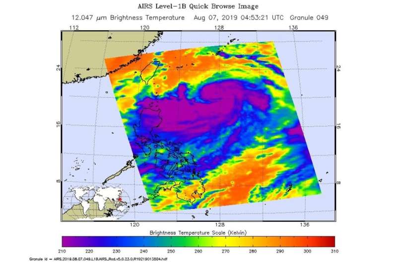
NASA's Aqua satellite captured this infrared image of Supertyphoon Lekima as it tracked 214 nautical miles southwest of Okinawa, Japan. Tropical cyclone warning signal #1 is in force for the Luzon provinces of Batanes and Babuyan group of islands. The storm has tracked north-northwest at 10 knots over the past six hours.
Satellite imagery shows this system continues to rapidly intensify as evidenced by tightly compact central convection which includes an eight nautical mile-sized eye with a tight pinhole in the eye which is an indication of a strong storm.
The supertyphoon is currently producing winds in excess of 130 knots (149 mph). On the Saffir-Simpson hurricane scale that would be a Category 4 hurricane. With the low vertical wind shear this storm seems well defined and coupled with warm sea surface temperatures of 30 degrees C (86 degrees F) the conditions will most likely allow the storm to continue to intensify.
Supertyphoon Lekima is expected to reach the east coast of China near Taizhou within 48 hours and is expected to sustain the current intensity due to favorable conditions. Interaction with land, however, will begin to weaken the storm to 60 knots (69 mph) by 72 hours, shortly after it crosses over Shanghai. At that point the storm will turn north-northwest and rapidly weaken as it continues further inland.
Provided by NASA's Goddard Space Flight Center


