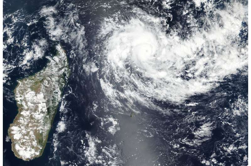
Satellite catches the eye of rapidly intensifying Tropical Cyclone Cilida

Tropical Cyclone Cilida appeared much more organized on satellite imagery as it moved across the southwestern Indian Ocean and continued to rapidly intensify. NASA-NOAA's Suomi NPP satellite captured a visible image of Cilida that showed a cloud-covered eye.
On Dec. 20, 2018 the Visible Infrared Imaging Radiometer Suite (VIIRS) instrument aboard NASA-NOAA's Suomi NPP satellite showed a powerful thunderstorms circling Cilida's 18 nautical mile wide eye and extending in bands northwest and southeast of the center. The VIIRS imagery revealed a cloud-covered eye as the storm reached hurricane-strength.
The Joint Typhoon Warning Center noted that Cilida had intensified rapidly, by 55 knots (63 mph/102 kph) in 24 hours. Rapid intensification is expected to continue in the near term as warm sea surface temperatures and light outside winds remain. However, Cilida is expected to run into increasing vertical wind shear (which can weaken a storm) ahead of a developing mid-latitude trough or elongated area of low pressure.
On Dec. 20 at 10 a.m. EDT (1500 UTC) Cilida's maximum sustained winds had reached 90 knots (103.6 mph/166.7 kph). Cilida is currently a Category 2 hurricane on the Saffir-Simpson Hurricane Wind Scale. It was located near 13.4 degrees south latitude and 58.9 degrees east longitude, approximately 427 nautical miles north-northeast of Port Louis, Mauritius. Cilida was moving southwestward and was undergoing rapid intensification.
Cilida is expected to pass to the east of Mauritius over Dec. 22 and 23 as it curves toward the southeast. In three to five days, Cilida is expected to undergo extratropical transition as it merges with the trough of low pressure.
Provided by NASA's Goddard Space Flight Center


