NASA analyzes newly formed Tropical Cyclone Cilidaa

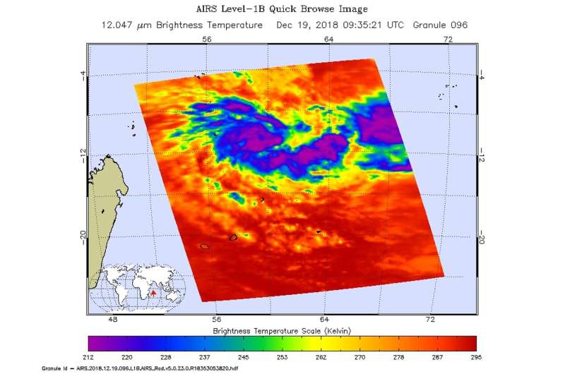
An infrared look by NASA's Aqua satellite revealed where the strongest storms were located within recently formed Tropical Cyclone Cilida. Cilida formed in the Southern Indian Ocean on Dec. 18.
On Dec. 19 at 4:35 a.m. EDT (0935 UTC) the Atmospheric Infrared Sounder or AIRS instrument aboard NASA's Aqua satellite analyzed cloud top temperatures of Tropical Cyclone Cilida in infrared light. AIRS found cloud top temperatures of strongest thunderstorms were south of the center. Coldest temperatures were as cold as or colder than minus 63 degrees Fahrenheit (minus 53 degrees Celsius). Cloud top temperatures that cold indicate strong storms that have the capability to create heavy rain.
Satellite imagery shows a consolidating system with a weak and partially exposed low level circulation. The Joint Typhoon Warning Center noted that "fragmented formative rain bands are spiraling in mostly from the east."
On Dec. 19 at 10 a.m. EST (1500 UTC), the center of Tropical Cyclone Cilida was located near latitude 11.6 degrees south and longitude 60.6 degrees east. That's about 544 nautical miles north-northeast of Port Louis, Mauritius. Cilida is moving to the south-southwest. Maximum sustained winds were near 35 knots (40 mph/65 kph).
Threatened landmasses include St. Brandon, Mauritius, and Rodrigues Island as Cilida is forecast to move southwest, and later southeast as it strengthens to 95 knots (109 mph/175 kph) after 4 days. The Joint Typhoon Warning Center expects Cilida to pass to the east of Mauritius on Dec. 22.
More information: For updated forecasts from Mauritius and Cilida's local effects, visit: http://metservice.intnet.mu/warning-bulletin-special-weather.php
Provided by NASA's Goddard Space Flight Center


