NASA finds wind shear affecting Tropical Storm Celia

Tropical Storm Celia continues to weaken in the Eastern Pacific Ocean and NASA data showed that the strongest winds and storms were pushed north of the center of the storm.
Hurricane Celia had weakened to a tropical storm with winds of about 45 knots (52 mph) when the Global Precipitation Measurement or GPM core observatory satellite flew over on July 14, 2016 at 0001 UTC (July 13 at 8:01 p.m. EDT). GPM found that convective storms were mainly located to the north and northeast of the Celia's center of circulation. GPM's Microwave Imager (GMI) and Dual-Frequency Precipitation Radar (DPR) found that rain was falling at over 164 mm (6.4 inches) per hour within the small area of a feeder band spiraling into the northeastern side of the center of circulation.
With this orbit GPM's radar (DPR Ku Band) made 3-D measurements of Celia's cloud tops and found that they were mainly shallow. A few cloud tops in the most powerful storms were measured by DPR reaching altitudes of over 11 km (6.8 miles).
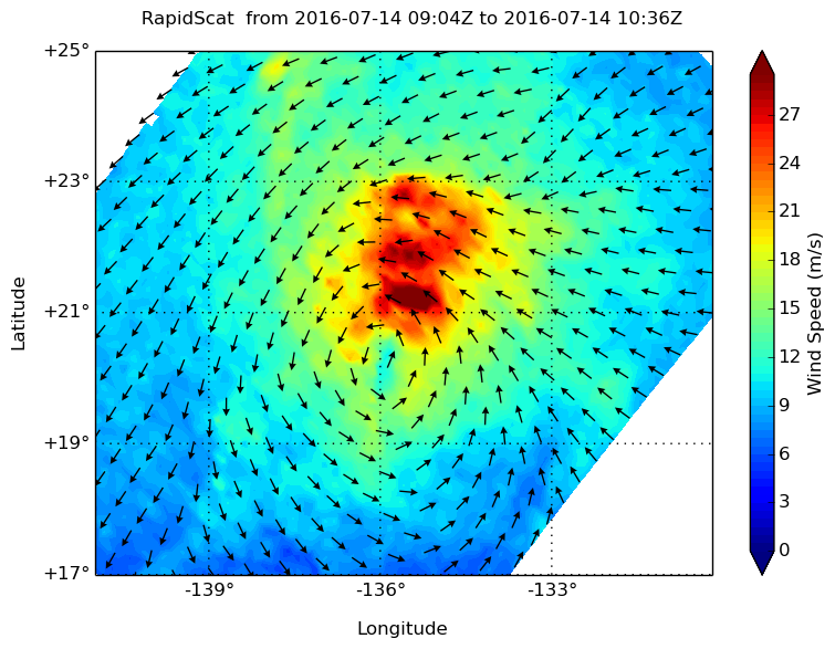
NASA's RapidScat instrument measured the surface winds around Tropical Storm Celia on July 11 between 0900 and 1000 UTC (5 and 6 a.m. EDT) and found the strongest winds north of the center of circulation near 30 meters per second (67 mph/108 kph).

The RapidScat instrument that flies aboard the International Space Station measures Earth's ocean surface wind speed and direction over open waters. Surface wind speed is always lower than speeds at higher altitude. RapidScat is an important tool for meteorologists, because it shows forecasters the location of the strongest winds in different quadrants of an area of low pressure or tropical cyclone as they are not always equally distributed.
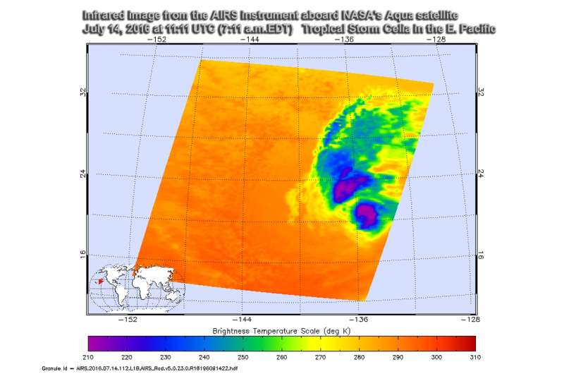
On July 14 at 11:11 UTC (7:11 a.m. EDT) the Atmospheric Infrared Sounder or AIRS instrument aboard NASA's Aqua satellite showed that Celia continued to maintain a small area of deep convection and coldest cloud top temperatures north of the center of circulation. The National Hurricane Center noted that "the area of cold cloud tops has become separated from the low-level center due to some southwesterly (wind) shear." Those cloud top temperatures are as cold as minus 63 Fahrenheit/minus 53 Celsius.
At 11 a.m. EDT (1500 UTC) on July 13 the center of Tropical Storm Celia was located near 20.8 north latitude and 136.7 west longitude. That's about 1,195 miles (1,920 km) east of Hilo, Hawaii. Celia is moving toward the west-northwest near 12 mph (19 kph) and the National Hurricane Center said that a turn toward the west is expected on Friday. Maximum sustained winds are near 50 mph (85 km/h) with higher gusts. Weakening is forecast, and Celia is likely to become a tropical depression early Friday, and degenerate into a remnant low by Friday night. July 15. The estimated minimum central pressure is 1000 millibars.
The National Hurricane Center said Celia is forecast to become a post-tropical cyclone in 24 to 36 hours. After that time, the cyclone will be moving over slightly warmer sea surface temperatures but moderate to strong westerly shear should prevent regeneration.
Once Celia passes west of 140W, warnings on this system will be issued by NOAA's Central Pacific Hurricane Center. Celia is expected to pass north of Hawaii and may bring rain to the northern islands on July 18 and 19.
Provided by NASA's Goddard Space Flight Center


