NASA analyzes first hurricane of the Eastern Pacific season

The second named tropical cyclone of the Eastern Pacific Ocean hurricane season has become a hurricane named Blas. NASA analyzed Blas in infrared light on July 5 and saw powerful thunderstorms with very cold cloud top temperatures after it reached hurricane status. Earlier, NASA's RapidScat instrument analyzed surface winds as the storm was strengthening from a depression to a tropical storm.
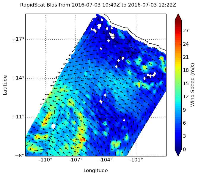
The tropical depression that grew to become Tropical Storm Blas formed at 11 p.m. (0300 UTC) on Saturday, July 2. At that time the center of Tropical Depression Three-E was near latitude 11.1 north and longitude 108.3 west. By 5 a.m. EDT on July 3 the depression strengthened into a tropical storm.
On July 3, the RapidScat instrument that flies aboard the International Space Station saw surface winds east of Blas' center near 21 meters per second (46.9 mph/75.6 kph). RapidScat is an important tool for meteorologists, because maximum sustained winds are not always equally distributed in a storm. RapidScat shows forecasters the location of the strongest winds in different quadrants of a storm, indicating locations facing greatest impacts.
By July 5, Blas had become the first hurricane of the Eastern Pacific hurricane season. At 5 a.m. EDT (0900 UTC) Maximum sustained winds have increased to near 100 mph (155 kph) with higher gusts.
The center of Hurricane Blas was located near latitude 14.2 North, longitude 118.1 West. That's about 805 miles (1,295 km) southwest of the southern tip of Baja California. Blas is far from land, so there are no coastal watches or warnings in effect.

Blas was moving toward the west-northwest near 14 mph (22 kph), and a motion toward the west-northwest or west is expected for the next couple of days. The estimated minimum central pressure is 978 millibars.
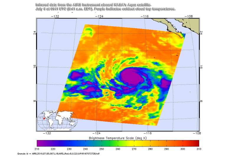
On July 5 at 0941 UTC (5:41 a.m. EDT) infrared data from the Atmospheric Infrared Sounder aboard NASA's Aqua satellite detected strong thunderstorms completely surrounding the center with temperatures colder than minus 75 degrees Celsius (minus 103 Fahrenheit). That indicates very powerful thunderstorms with cloud tops high into the troposphere. Infrared data also suggests a ragged eye has developed.
Visible satellite data shows that the overall convective cloud pattern has also become more symmetrical.
The National Hurricane Center (NHC) said that additional strengthening is expected, and Blas is forecast to become a major hurricane later today, July 5. NHC noted that in two days, Blas will be moving over cooler waters that will put the storm on a weakening trend. For updates, visit: http://www.nhc.noaa.gov.
Provided by NASA's Goddard Space Flight Center


