NASA looks at Japan's torrential rains and winds from twin tropical cyclones

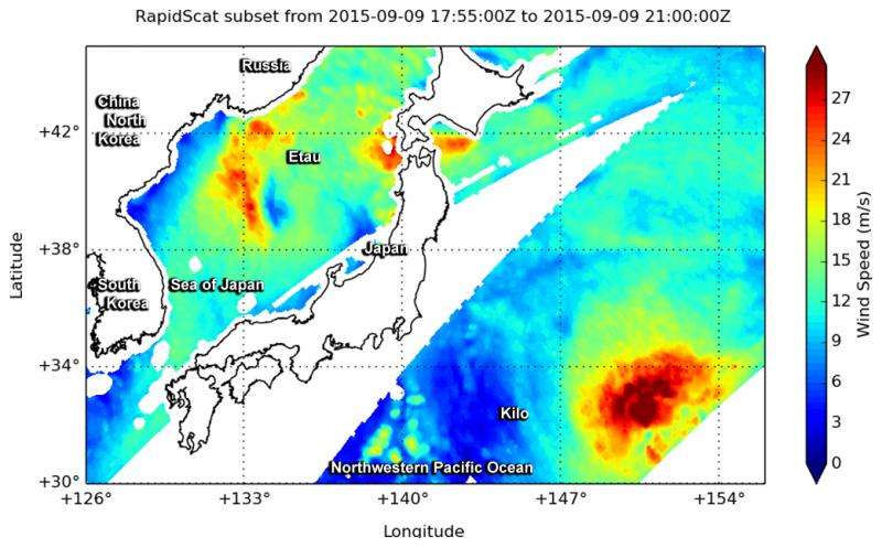
Japan has experienced large rainfall that caused flooding and large evacuations as a result of two weather systems. NASA's GPM Core satellite measured rainfall as NASA's RapidScat saw Etau and Typhoon Kilo on either side of Japan.
Over the past week Japan has experienced extreme rainfall that resulted in flooding, landslides and many injuries. A nearly stationary front that was already moving over Japan caused much of the rain but Tropical Storm Etau also interacted with the front and magnified the scale of the deluge.
Heavy rainfall led to the evacuation of over one million people. The area around the city of Joso, located in the Ibaraki prefecture and north of Tokyo, received as much as 600 mm (24 inches) of rainfall. The Aichi prefecture where Joso is located received rainfall and winds near 78 mph (125 kph). According to the Japan Meteorological Agency, the hardest-hit areas were the Ibaraki and Tochigi prefectures
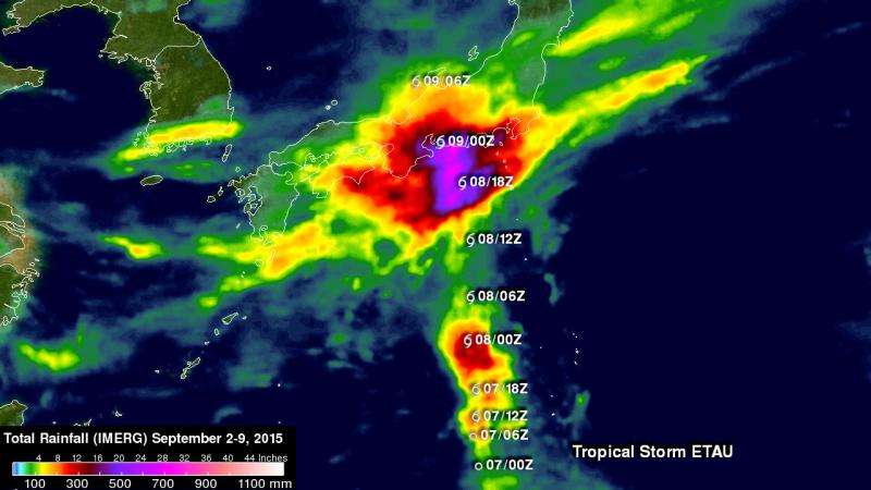
The Global Precipitation Measurement (GPM) core satellite provided rainfall data on the weather system. This rainfall analysis from space was generated at NASA's Goddard Space Flight Center in Greenbelt, Maryland, using NASA's Integrated Multi-satellite Retrievals for GPM (IMERG) data. It shows rainfall total estimates for Japan during the seven day period from September 2 to 9, 2015 when Japan was getting drenched.
This analysis indicates that much of Japan's main island of Honshu had over 100 mm (almost 4 inches) of rainfall. Extraordinary totals of over 750 mm (29.5 inches) were analyzed near the south-central coast of Honshu near where tropical storm Etau passed over the island.
After landfall in Japan, Tropical Storm Etau moved northward into the Sea of Japan. "RapidScat saw Etau on Sept 9 at 3:20 a.m. UTC (Sept. 8 at 11:20 p.m. EDT), still entangled with Japan and again near 4 p.m. EDT (20oo UTC) with a well-formed spiral," said Doug Tyler of NASA's RapidScat team at NASA's Jet Propulsion Laboratory in Pasadena, California. The evening picture shows Japan bracketed by Kilo to the east, and Etau to the west, in the Sea of Japan.
On September 10, satellite imagery showed Etau's remnants over the Primorsky Krai territory of southeastern Russia on the Sea of Japan. Meanwhile, Typhoon Kilo continued moving northward in the Northwestern Pacific Ocean.

Provided by NASA's Goddard Space Flight Center


