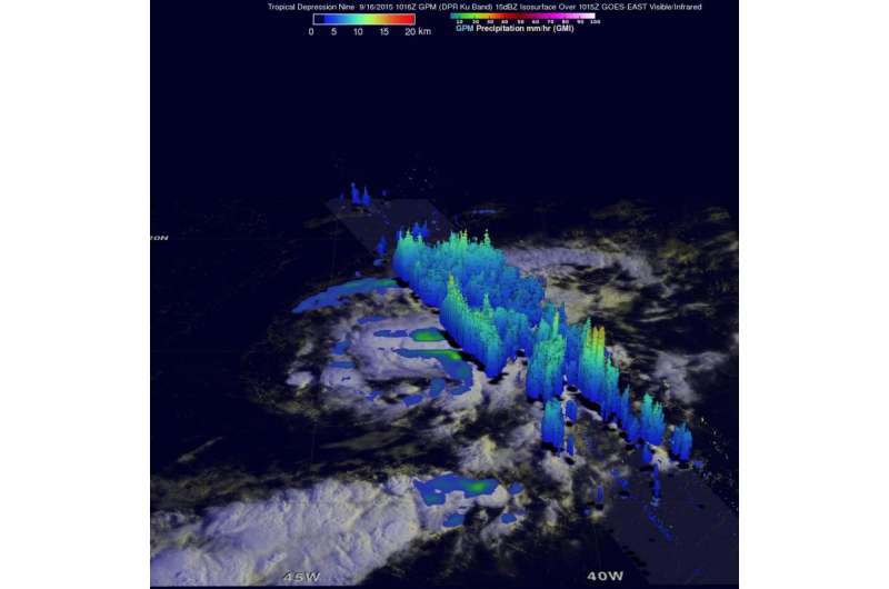
NASA's GPM analyzes Tropical Depression 9 rainfall

The Global Precipitation Measurement or GPM mission core satellite passed over Tropical Depression 9 in the Central Atlantic and looked at the rainfall rates within the storm.
Tropical cyclone development has been relatively slow in the Atlantic Ocean in 2015 with tropical depression Nine (TD9) forming yesterday, September 16 in the central tropical Atlantic.
GPM's Microwave Imager (GMI) and Dual-Frequency Precipitation Radar (DPR) instruments collected data on Sept. 16 at 1016 UTC (6:16 a.m. EDT). At NASA's Goddard Space Flight Center in Greenbelt, Maryland, data from that overpass (or flyover) were used to create a three dimensional (3-D) extent of Tropical Depression Nine's (TD9) rainfall. GPM's 3-D DPR (Ku Band) found that the tallest convective thunderstorms within TD9 were reaching heights of about 14.9 km (9.2 miles) in a feeder band southeast of TD9's center of circulation. The most intense rain was measured by GPM falling at a rate of 58.2 mm (2.3 inches) per hour.
The GPM core satellite is managed by both NASA and the Japan Aerospace Exploration Agency.
At 5 a.m. EDT on September 17, 2015 the center of Tropical Depression Nine was located near latitude 16.3 North and longitude 45.3 West. That puts the center about 1,065 miles (1.715 km) east of the Lesser Antilles. The depression was moving toward the northwest near 7 mph (11 kph), and this general motion is expected to continue for the next couple of days.
Maximum sustained winds are near 35 mph (55 kph) and the National Hurricane Center (NHC) expects some weakening is expected during the next couple of days. In fact, the NHC said that the depression could degenerate to a remnant low pressure area by Saturday, September 19. For the latest forescasts on TD9, visit the National Hurricane Center webpage: http://www.nhc.noaa.gov.
Provided by NASA's Goddard Space Flight Center


