NASA sees comma shaped Tropical Storm Kilo

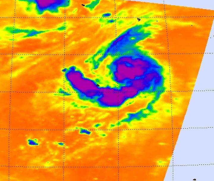
Tropical Storm Kilo looks like a giant comma from space in imagery from NASA's Aqua satellite. Kilo continues to strengthen and was affecting Johnston Island as a tropical storm warning continued on August 28.
NASA's Aqua satellite passed over the tropical storm on August 27 at 13:05 UTC (9:05 a.m. EDT. The Atmospheric Infrared Sounder or AIRS instrument aboard Aqua looked at the storm in infrared light, measuring temperatures of cloud tops and surrounding sea surface to help determine where the strongest parts of the storm are, and if the waters surrounding the storm would help it maintain strength.
AIRS showed the strongest thunderstorms stretched high into the troposphere (the lowest layer of the atmosphere) around the center of circulation and in a band of thunderstorms that extended from the center to the south and west, giving the appearance of a giant comma. Cloud-top temperatures in both of those areas were as cold as or colder than -63 Fahrenheit (-53 Celsius), indicating high, powerful thunderstorms with the capability to generate heavy rainfall.
In the image, Johnston Island was near the end of the "tail" of the comma. That means that the island was experiencing tropical storm conditions which are expected to diminish late on August 28. Heavy showers and thunderstorms from Kilo were affecting Johnston Island bringing an additional rainfall amounts of 2 to 4 inches. The Central Pacific Hurricane Center noted that large surf will continue on the island on August 28, especially along northwest and north facing shores and reefs.
At 11 a.m. EDT (1500 UTC) the center of Tropical Storm Kilo was located near latitude 17.2 north and longitude 170.6 west. Maximum sustained winds were near 70 mph (110 kph) and the CPHC expects Kilo to become a hurricane and slowly intensify during the next couple of days.
Kilo was moving toward the west near 8 mph and is expected to gradually turn west-northwest on August 29. The estimated minimum central pressure is 990 millibars. For updates, visit the CPHC website at: http://www.prh.noaa.gov/cphc.
Provided by NASA's Goddard Space Flight Center


