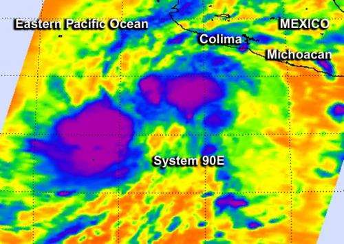
NASA watching year's first tropical low headed for southwestern Mexico

There's a tropical low pressure area in the Eastern Pacific Ocean today, about 8 days before the official Eastern Pacific hurricane season begins. NOAA's National Hurricane Center is giving it a 50 percent chance of becoming a tropical depression in the next two days, and NASA's Aqua satellite passed overhead to gather infrared data on it.
NASA's Aqua satellite passed over developing tropical low pressure system 90E on May 8 at 08:41 UTC (4:41 a.m. EDT) and infrared data from the Atmospheric Infrared Sounder (AIRS) instrument aboard, showed that some of the thunderstorms had high, cold cloud top temperatures as cold as -63F/-52C, indicating there was some strong uplift in the system.
According to the National Hurricane Center (NHC), System 90E is a broad area of low pressure located about 400 miles south-southwest of Manzanillo, Mexico (south-southeast of Michoacán state coast). The low pressure area consists of a large area of cloudiness and thunderstorms. The system is still organizing and satellite data suggest that it still lacks a well-defined center.
NHC expects System 90E to move northeastward toward the southwestern coast of Mexico, so residents should pay attention to it. According to NOAA, conditions today, May 7 at 12:00 p.m. EDT at Colima, which is located on the southwestern Mexico coast, were mostly cloudy skies with calm winds and a temperature of 71F (22C).
Even if not a tropical depression, low pressure areas containing thunderstorms with cold cloud top temperatures as those seen in today's AIRS imagery, can still drop heavy rainfall. NHC noted that "Regardless of development...locally heavy rains will begin to affect portions of southwestern Mexico today."
NHC says that this systems as a medium chance (50 percent) of becoming a tropical cyclone during the next 2 day and 5 days.
Provided by NASA's Goddard Space Flight Center


