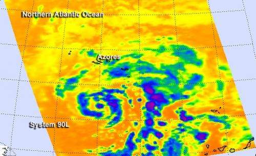
Atlantic Ocean's system 90L gets an infrared NASA look

NASA's infrared instrument called AIRS that flies aboard the Aqua satellite gave scientists another look at the clouds and convection happening in a non-tropical low pressure area that's struggling to organize into a sub-tropical or tropical cyclone.
NASA's Aqua satellite passed over System 90L on Dec. 5 at 9:47 a.m. EST and the Atmospheric Infrared Sounder or AIRS instrument captured infrared data on the clouds, revealing the strongest thunderstorms east of the center. The bands of thunderstorms east of the center appeared fragmented in the infrared imagery. Within the bands, some of the cloud top temperatures were near -63F/-52C, indicative of high clouds with the potential for moderate to heavy rainfall. On Dec. 6, the heaviest shower activity was still falling east of the center, and some strong showers were also located north of the center of circulation.
The non-tropical area of low pressure was centered about 250 miles south of the Azores Islands and generating gale-force winds.
The National Hurricane Center noted that this post-Atlantic Hurricane Season wannabe is headed northward and into an area of stronger upper-level winds, wind shear and cooler waters, all of which will weaken the system. The National Hurricane Center gives this low pressure area just a 20 percent chance of becoming a subtropical or tropical cyclone during the next five days.
Provided by NASA's Goddard Space Flight Center


